|
Confederate leaders saw the value of expanding
the Southern railroad network in numerous places. Most of
these construction projects had been discussed as commercial
ventures before the war and some of their backers saw this as
an opportunity to push construction of their projects with
Confederate Government support and money. Many roads not
listed were chartered during the war, but they did not sell
enough stock to officially organize and did no construction
work. (Roads continuing work on their original road's plan are
not listed.) |
|
Connection |
Status |
|
Alabama |
| Selma, Al. to Meridian, Miss.
(the Alabama
& Mississippi Rivers Railroad) |
| This 104-mile road had been started before the war
as a connection in the Montgomery to Vicksburg route.
With the Memphis & Charleston RR very vulnerable
to being broken at Memphis or on the Tennessee River,
it was critical for the South to create a second rail
route across the lower Confederacy. This line was part
of the solution, but lacked two sections -- 5 miles on
the Tombigbee River and the 45 miles from Selma to
Montgomery, filled in by the steamboats on the Alabama
River. Except for the Tombigbee bridge, the road was
completed in December 1862 from Selma to Vicksburg. |
|
| Blue Mountain, Al. to Rome, Ga. |
| This was a 61-mile extension of the Alabama & Tennessee River Railroad
to make a connection in the rear of the Army of
Tennessee so that it could be supplied without relying
solely on the Western & Atlantic RR. The route was easy
and grading almost completed. The Georgia portion of the
road (22 miles) was chartered in Georgia as the Georgia
& Alabama RR; Alfred Shorter was the first President of
the Georgia road, followed by A. M. Sloan; C. M.
Pennington was Chief Engineer in 1861 and George
Wadsworth was in 1862 and 1863. Charles H.
Smith appears to have been Secretary and Treasurer for
both roads. This road was
planned well before the war and the Georgia Legislature
had given Rome permission to subscribe $100,000 to the
road at that time. |
| NP, RC 5-4-61 |
|
NA,
QMR 11-28-61 |
|
NP,
JR 2-20-62 |
|
NP,
JR 3-20-62 |
|
NP,
JR 6-5-62 |
| OR Series 1, Vol. 17, Part 2, Page 756 |
| NA, ENG 9-16-62 |
| AOC, 10-2-62 |
|
NP,
REX 10-7-62 |
|
NP, JR 10-16-62 |
|
NP, JR 10-16A-62 |
|
NA,
ENG 10-22C-62 |
| NP, SMR 10-22-62 |
|
OR Series 4, Vol. 2, Page 139 |
|
OR Series 4, Vol. 2, Page 144 |
|
NA,
ENG 10-31-62 |
|
AHC,
LPG 11-1A-62 |
|
AHC,
LPG 11-11-62 |
| NA, ENG 11-11-62 |
|
NA,
ENG 11-11B-62 |
| NA, ENG 11-12-62 |
| NP, RSTD 11-12D-62 |
|
AHC,
LPG 11-13-62 |
|
AHC,
LPG 11-13A-62 |
|
AHC,
LPG 11-14-62 |
|
AHC,
LPG 11-15-62 |
|
AHC,
LPG 11-17-62 |
|
AHC,
LPG 11-17A-62 |
| NA, ENG 11-19-62 |
| OR Series 4, Vol. 2, Page 139 |
|
AHC,
LPG 11-24-62 |
| NA, ENG 12-2-62 |
| NA, ENG 12-2B-62 |
|
AHC,
LPG 12-3-62 |
|
AHC,
LPG 12-3A-62 |
|
AHC,
LPG 12-3A-62 |
|
AHC,
LPG 12-5-62 |
|
AHC,
LPG 12-5A-62 |
|
AHC,
LPG 12-6-62 |
|
AHC,
LPG 12-6A-62 |
| NA, ENG 12-9B-62 |
|
AHC,
LPG 12-11-62 |
|
AHC,
LPG 12-16-62 |
|
AHC,
LPG 12-16A-62 |
|
AHC,
LPG 12-31-62 |
| NA, A&TR 1-1-63 |
|
AHC,
LPG 1-5-63 |
|
AHC,
LPG 1-5A-63 |
|
NA,
ENGR 1-5-63 |
|
NA,
ENGR 1-5A-63 |
|
AHC,
LPG 1-6-63 |
|
AHC,
LPG 1-6A-63 |
| NP, ASCY 1-8-63 |
|
NP,
RC 1-16-63 |
|
NA,
ENG 1-17D-63 |
|
AHC,
LPG 1-22-63 |
| NA, ENG 1-30-63 |
| NP, ASCY 2-3-63 |
|
NP,
JR 2-5-63 |
|
NP,
JR 2-5A-63 |
|
NP,
JR 2-5B-63 |
|
NP,
JR 2-5C-63 |
|
NP,
JR 2-5D-63 |
| SOR, Series 95, Page 123 |
| NP, ASCY 2-10-63 |
|
AHC,
LPG 2-16-63 |
|
AHC,
LPG 2-16A-63 |
|
AHC,
LPG 2-17-63 |
| NP, MT 2-19-63 |
|
AHC,
LPG 2-19A-63 |
|
AHC,
LPG 2-20-63 |
|
NA,
ENGR 2-20-63 |
|
AHC,
LPG 2-24-63 |
| NP, YE 2-25-63 |
|
NA, ENG
2-27-63 |
| NP, ASCY 3-7-63 |
| NA, ENG 3-10C-63 |
| NP, ASCY 3-11-63 |
|
NA,
ENGR 3-12-63 |
|
AHC,
LPG 3-13A-63 |
|
NP,
JR 3-19-63 |
|
NA,
ENG 3-26B-63 |
| NA, ENG 4-11-63 |
|
NA,
ENG 4-16A-63 |
|
NA,
ENG 4-16B-63 |
|
NA,
ENGR 4-19-63 |
|
AHC,
LPG 4-20-63 |
|
AHC,
LPG 4-28-63 |
|
NA,
ENGR 4-28-63 |
|
AHC,
LPG 5-4-63 |
|
NA,
ENGR 5-4A-63 |
|
NA, ENG
5-5E-63 |
|
NA,
ENGR 5-5-63 |
|
NA,
ENGR 5-7-63 |
|
NP,
NGT 5-8-63 |
|
NP, NGT 5-8A-63 |
|
NP, NGT 5-8B-63 |
|
AHC,
LPG 5-11-63 |
|
NA, ENG
5-18-63 |
| NA, ENG 5-23B-63 |
|
AHC,
LPG 5-27-63 |
|
AHC,
LPG 5-27A-63 |
|
NA,
ENGR 5-27-63 |
| NA,
A&TR 6-2-63 |
|
NA,
ENGR 6-8-63 |
| NA, ENG 6-16A-63 |
| NA, ENG 6-16B-63 |
| NA, ENG 6-19B-63 |
|
NA,
ENGR 6-19-63 |
|
AHC,
LPG 6-20-63 |
|
NA,
ENG 6-20B-63 |
|
OR Series 1, Vol. 23, Part 2, Page 453 |
| NA,
RR 6-30-63 |
|
AHC,
LPG 7-11F-63 |
|
NA,
ENGR 9-3A-63 |
| NA, ENG 9-4B-63 |
| NA, ENG 9-5-63 |
|
NA, ENG
9-7B-63 |
| OR Series 1, Vol. 28, Part 2, Page 410 |
|
NP, JR 10-10-63 |
| NA, ENG 10-16A-63 |
|
NA,
ENGR 10-19-63 |
|
AHC,
LPG 10-20-63 |
| NP, AI 10-29-63 |
| OR Series 1, Vol. 31, Part 3, Page 787 |
|
AHC,
LPG 12-15A-63 |
|
NA, ENG
1-8-64 |
|
AHC,
LPG 1-9-64 |
|
NA,
ENGR 3-5-64 |
| OR Series 1, Vol. 52, Part 2, Page 641 |
| OR Series 1, Vol. 52, Part 2, Page 647 |
|
NA,
ENGR 4-4A-64 |
| NA, ENG 4-14A-64 |
| NA, ENG 4-28A-64 |
|
NA,
DAMELA 5-4-64 |
| NA, ENG 5-17-64 |
| NA, ENG 5-18B-64 |
| NA, ENG 5-19-64 |
|
NP,
JR 5-21-64 |
| NA, ENG 6-15-64 |
|
NA,
DAMELA 6-16-64 |
| NA, ENG
6-24J-64 |
| NA, ENG
7-22F-64 |
|
AHC,
LPG 7-28A-64 |
|
NA,
ENGR 7-28-64 |
|
NA, ENG
8-6C-64 |
|
NA, ENG
8-6D-64 |
| OR Series 1, Vol. 39, Part 1, Page 796 |
|
|
Montgomery, Al. to Columbus, Ga.
(via Union Springs, Al.) |
| This 100-mile road would
have been of great value by allowing shipments to remain on
the same gauge cars from Mobile to North Carolina,
circumventing the smaller gauge Montgomery & West Point
Railroad. This route would use the first section of the
Montgomery & Eufaula RR (Montgomery to Union Springs, 39
miles) and then the Mobile & Girard RR from Union
Springs to Girard (across the river from Columbus.) Grading was almost complete
to Union Springs in September, 1864 and
the request was made to use iron being removed from
other Georgia RRs to finish the work.
It is unclear whether the road was completed during the
war. |
| NA, ENG
7-26-64 |
| NA, ENG
7-26C-64 |
|
NA, ENG
8-2-64 |
| NA, ENG
8-6B-64 |
| NA, ENG
8-13A-64 |
| OR Series 1, Vol. 39, Part 2, Page 872 |
|
NA,
DAMELA 9-30-64 |
|
NA, QMR
10-5-64 |
|
NP,
CT 10-10A-64 |
|
NA, CS
10-15-64 |
|
NA,
DAMELA 10-15-64 |
|
NA,
QMR 10-15A-64 |
| NA, QM 10-21-64 |
|
NA, CS
10-29-64 |
|
NA,
ENGR 11-4-64 |
|
NA,
ENGR 11-4B-64 |
|
NA,
ENGR 11-5-64 |
|
NA,
ENGR 11-19-64 |
| NP, SM 11-20-64 |
| NA,
RR 2-11-65 |
| OR Series 4, Vol. 3, Page 1095 |
| NA,
RR 2-28A-65 |
|
NP,
CE 6-27-65 |
|
|
Blue
Mountain, Al. to Jacksonville, Al. |
| This briefly considered
road would have been about 20 miles long. Its purpose was to
reduce the length of the wagon haulage from the railhead to
the Army of Tennessee, at Gadsden, Al. The saving of 5 miles
of wagon effort was out of all proportion to the effort
required to haul the iron to the work site. No work was done
and the Army soon moved out of Gadsden. Jacksonville to Blue
Mountain was part of the Blue Mountain to Rome, Ga. line
that had been pushed in early 1863. The branch to
Gadsden had been a planned part of the Alabama & Tennessee River
RR from its early days. |
| OR Series 4, Vol. 3, Page 742 |
|
AR, A&TR 4-1-66 |
|
|
Montgomery, Ala. to Selma, Ala.
(the Western Rail Road of Alabama)
|
| This 77 mile road would have completed
an all-rail route from Vicksburg to Charleston and was
of vital importance. The road was chartered in 1860 and
was surveyed the same year. According to the 1862 annual
report of the Montgomery & West Point RR, the entire
road was placed under contract by January 1, 1862, with
grading to be finished by the end of the year and
arrangements were being made to secure the same type aid
offered by the Government to the construction between
Selma and Meridian. In July 1862, the Secretary of War
was writing about the source of iron for the road. A
November 1862 ad calls for 100 hands to work on the
western 15 miles of the road. The route of the road was
very difficult because the land on the shortest route
was very low and swampy. It is very unlikely that any
iron was laid on this road during the war. The leader of
the effort to build this road was C. T. Pollard, who was
President and Samuel C. Jones was probably Chief
Engineer. |
|
Western of Alabama Railroad Map |
| NP, NOTP 1-12-62 |
| NA, M&WP 1-23-62 |
|
NP, NOTP 2-13-62 |
| NA,
SWT 7-15-62 |
| NP, SMR 11-26-62 |
| NA,
RR 2-11-65 |
| OR Series 4, Vol. 3, Page 1095 |
| NA,
RR 2-28A-65 |
|
|
Meridian, Miss.
to Chattanooga, Tn.
(the Northeast & Southwest
Alabama Railroad) |
| This 207-mile
road had just begun construction when the war began -- only 27
1/2 miles had been laid. In early 1863, the road requested a
loan in order to complete the road. It would have provided
another route into Chattanooga to support the Army of
Tennessee and would have tapped the very rich iron and coal
belts of central Alabama. The great amount of work remaining
and the lack of iron prevented the Government's giving the
loan to complete the road, though the Engineer Bureau did
recommend the completion of the southern 123 miles of the
uncompleted portion.
|
| NA, ENG 4-4-63 |
|
|
Calera, Ala. to Oxmoor,
Ala.
(the South & North Alabama Railroad) |
|
The road was a wartime expedient
to connect Red Mountain to Selma, Alabama. The route used the one
already surveyed for the unbuilt Alabama Central Railroad. It started at
iron furnaces near Shades Mountain and connected to the Alabama &
Tennessee River Railroad at Calera. It was extended from Shades Mountain
to Oxmoor in late 1863, a total of 25 miles. |
| NA, A&F 4-3-63 |
| B8, ALA 4-16-64 |
| NA, QM 10-1-64 |
|
|
Shelby Iron Works
to
the Alabama & Tennessee River Railroad
(Shelby Iron Company Railroad) |
|
This 5-mile road was a wartime expedient to connect the Shelby
Iron Company to the Alabama & Tennessee River RR. The local
Confederate Ordinance official prevented the construction for
over two years by threatening to have senior Company employees
conscripted if they diverted iron to make rails for the road. Construction began in
1863 and was completed in January, 1865. |
| B8, ALA 4-16-64 |
|
|
Strother Iron Works,
Ala.
|
|
A 1 1/2 mile road from the Alabama & Tennessee River RR, at
Ashby, Ala., was graded to the Iron Works. No iron was laid
during the war. Additional grading extended 2 1/2 miles toward
the coal fields between the Cahaba and Little Cahaba Rivers. |
| NP, TAR 2-25-64 |
|
|
Selma & Gulf RR
|
|
This 59 mile road was chartered in 1858 as one small part of a
Nashville to Gulf (Pensacola was the primary goal) road. The
charter gave permission to build
due south from
Selma to a connection with the Mobile & Great Northern RR,
the Mobile & Girard RR or the Alabama & Florida (of
Alabama) RR. Grading from Selma to about Pine Apple (40 miles
south) was practically completed when the war started. It is
unlikely any additional work was done, beyond finishing the
grading of that leg. It was reported in 1860 that 43 miles of
iron had been ordered, but it was not received. William T. Minter was President,
Y. L. Yuille was Chief Engineer and Willis
S. Burr was Secretary and Treasurer. |
| NP, SMR 4-19-61 |
|
AL,
S&G 12-5-61 |
|
AHC,
A&MR 12-9-61 |
| NP, SMR 2-16-62 |
| NA,
S&G 8-29-63 |
|
|
Tennessee & Cossa RR
|
This 37 mile road was to connect the Alabama & Tennessee River
RR at Gadsden to Gunter's Landing and the Winchester & Alabama
RR. The road was ready for iron in June of 1861. H. S. Rayburn
was President in 1861
|
|
Opelika & Tuscumbia RR
|
A 232-mile road that was chartered in 1854 and again in 1859 to
Talladega and was graded to Waverley in 1861; it was intended to pass through Dadeville to
Childersburg and Talladega, with a major extension (and name
change) to Tuscumbia approved in late 1861. The President was John R. Slaughter, Chief
Engineer was A. H. Barnett, and Secretary & Treasurer was W. G.
Williams. See 3/30/61 article for Directors. The Georgia
Legislature gave Columbus, Ga. permission to subscribe to the
road. The road was sometimes called the Savannah & Memphis RR
and formally took that name in 1866.
|
NP,
SR 2-2-61 |
|
NP,
SR 3-16-61 |
|
NP, SR 3-16A-61 |
| NP, SoR 3-23-61 |
| NP, SoR 3-30-61 |
|
NP,
JR 4-25-61 |
|
NP,
SMN 7-12-61 |
| UG, O&T 9-11-61 |
|
AL, O&T 11-9-61 |
|
AL, A&F 12-3-61 |
| NP, MT 10-13-63 |
|
NA, RR
7-24-64 |
|
|
Opelika & Oxford RR |
This 90-mile road would connect Opelika, on the
Montgomery & West Point RR, to Oxford, on the Alabama &
Tennessee River RR. Contracts for grading the first sixteen
miles (to Lafayette) were let in June 1860; one-third of the
grading and two-thirds of the culverting was completed before
the war stopped work. Judge E. G. Richards was President and O.
P. Rogers was Chief Engineer.
|
|
Gainesville to Selma
|
This 75-mile road was desired by the Government, but could not
be constructed because of the lack of iron. A plank road was
seen as a substitute, but I have found no information that it
was constructed.
|
|
Mobile to Pensacola |
Since a road of this name already existed in Florida, it is not
known what name would have been used. The road would have
started at Blakely, Alabama, just above Spanish Fort, and met
the Florida Pensacola & Mobile RR at Hall's Bridge on the
Perdido River. The existing Florida RR would have been used to
reach Pensacola -- 35 miles of new track and 30 miles of
existing track. No evidence has been found of any actual work
having been started on this road.
|
|
Arkansas |
|
Little Rock & Fort Smith RR
|
| This 163-mile long road was authorized in
1853. Grading was
done, but no iron was laid until 1870. Jesse Turner was
President from the beginning until after the war. S. Martin was the Secretary in
1861. |
| NP, ARG 4-27-61 |
|
|
Mississippi, Ouachita & Red River RR
|
| A 155-mile road that was incorporated in
1851, chartered in 1852 and organized organized in 1854.
The road was intended to run from present Arkansas City,
on the Mississippi River, to the Red River, at
Lewisville, by way of Monticello and Camden. It would
open up 1.5 million prime cotton acres, a large corn
area, coal from Camden and be part of the Charleston to
San Francisco route. According to the Arkansas
Encyclopedia of History & Culture, 7 miles headed south
and west from the Mississippi River when the war
started, but the road was not operational. A January,
1860 article quotes the President as saying 1 1/2 miles
were in operation and eight more miles of iron had been
purchased. The same President
of the road said in January, 1861, that it was
operating freight and passenger cars daily, and a
soldier mentions getting a free ride on the road. The iron was
sold to the Confederate Army and removed in late 1862.
James Thomas Elliott was the President. Directors for
1862 are in the 12/11/61 article. |
|
NP,
AG 1-21-60 |
|
NP, ATD 1-12-61 |
|
NP, STD 2-2A-61 |
|
NP, ATD 8-15-61 |
| NP, MAP 12-11-61 |
|
NP, ATD 12-19-61 |
|
NP,
ATD 1-2-62 |
| NP, WT 1-15A-62 |
| NP, WT 2-15-62 |
|
B20,
MO&RR 4-3-62 |
| NP, ARG 10-18-62 |
| NA,
MO&RR 11-27-62 |
| NA,
MO&RR 12-31-62 |
|
NP,
WT 3-11-63 |
|
MISC, MO&RR 7-27-64 |
|
|
Florida |
|
Lawton, Ga. to Live Oak, Fl.
|
| This 49-mile connection between the Pensacola & Georgia Railroad
and the Savannah, Albany & Gulf Railroad
was opposed by many Florida railroad men before the war. It was
feared that goods would travel by rail to Savannah or
Charleston, rather than to Jacksonville; it would also destroy
the rationale for the Florida Railroad. Construction, however,
was begun in 1861 by the two companies. Confederate leaders
wanted the road completed to enable them to send troops to defend
Florida (without having to station them there) and to enable
them to draw food (particularly beef) from Florida.
Construction was essentially completed by May of 1863, but
completion was slowed because of the lack of iron; enough was
eventually obtained by removing it from the Florida Railroad,
despite court injunctions. The road was completed in March of
1865. |
|
NP, SMN 3-20A-61 |
| AR, SA&G 5-1-61 P |
| OR Series 4, Vol. 1, Page 612 |
| OR Series 4, Vol. 1, Page 777 |
| FA, P&G 12-14-61 |
|
NA,
P&G 12-26-61 |
|
FHS,
FL 12-31-61 |
|
FHS,
FL 12-xx-61 |
| AR, A&G 2-1-62 E |
| NP, MAR 2-15-62 |
| NP, MT 8-1-62 |
| UF, F
3-10-62 |
| UF, P&G 3-13-62 |
|
NA, QMR
3-18-62 |
| UF, F 3-19-62 |
| OR Series 1, Vol. 53, Page 224 |
|
NA,
QMR 3-31A-62 |
| NA, QM 4-3-62 |
|
NA, QMR
4-27-62 |
| AR, SA&G 5-1-62 P |
| AR, SA&G 5-1-62 E |
|
FHS,
FL 11-10-62 |
|
NP,
SMN 12-6-62 |
| OR Series 1, Vol. 53, Page 274 |
| NA, ENG 2-6-63 |
|
FHS,
FL 3-30-63 |
|
AR, P&G 4-1-63 P |
|
NP,
SMN 4-29-63 |
|
FHS,
FL 5-21A-63 |
|
FHS,
FL 5-23-63 |
|
NA,
ENGR 5-24-63 |
| NA, ENG 5-27C-63 |
|
FHS,
FL 5-30-63 |
|
NA, SWR
6-8-63 |
|
NA, FL
6-29-63 |
|
NA,
DSCGF 7-6-63 |
| NA, ENG 8-10B-63 |
| NA,
ENG 8-15-63 |
|
FHS,
FL 9-16-63 |
| OR Series 1, Vol. 28, Part 2, Page 459 |
|
NA,
ENGR 10-30A-63 |
| NA, ENG 11-2B-63 |
| NA, ENG 11-20A-63 |
| NA, ENG 11-21-63 |
| NA, ENG 12-3-63 |
| OR Series 1, Vol. 31, Part 3, Page 787 |
|
NA,
DSCGF 2-10-64 |
|
NA,
ENGR 2-15-64 |
| OR Series 1, Vol. 35, Part 1, Page 631 |
| OR Series 1, Vol. 35, Part 1, Page 632 |
| NA, ENG 2-22C-64 |
| NA, ENG 2-26-64 |
|
NA,
ENGR 2-19-64 |
| NA, ENG 3-4A-64 |
| OR Series 1, Vol. 35, Part 2, Page 333 |
| NA, ENG 3-10-64 |
|
NA, DF
3-11C-64 |
|
NA,
DSCGF 3-21-64 |
|
NA, RR
3-21-64 |
| OR Series 1, Vol. 35, Part 1, Page 321 |
| UF, A&G 4-6-64 |
| OR Series 1, Vol. 35, Part 2, Page 431 |
|
NA,
DSCGF 4-28-64 |
|
NA, FL
4-28-64 |
|
NA, DF
4-30-64 |
|
NA, DF
5-2-64 |
|
NA, QMR
5-2C-64 |
|
NA, DF
5-3-64 |
| NA,
L&LO 5-3-64 |
|
NA, DF
5-5-64 |
|
NA,
DSCGF 5-14-64 |
|
NA, RRB
5-30-64 |
|
NA, L&LO 5-31-64 |
|
NA,
DSCGF 6-2-64 |
|
NA,
DSCGF 6-2A-64 |
| NA, ENG 6-10A-64 |
| NA, ENG 6-10B-64 |
|
NA,
DSCGF 6-11-64 |
| NA, ENG
6-16-64 |
| NA, ENG
6-21A-64 |
| NA, ENG
7-1B-64 |
|
NA,
DSCGF 7-5-64 |
|
NA, RRB
7-5C-64 |
| NA, ENG
7-7A-64 |
| NA,
L& LO 7-16-64 |
| OR Series 1, Vol. 35, Part 2, Page 594 |
| OR Series 4, Vol. 3, Page 560 |
| OR Series 1, Vol. 35, Part 2, Page 606 |
| NA,
RRB 10-18A-64 |
|
NA, DF
10-21-64 |
| NA,
RR 11-30-64 |
| OR Series 1, Vol. 47, Part 2, Page 983 |
| OR Series 1, Vol. 47, Part 2, Page 1005 |
| OR Series 1, Vol. 47, Part 2, Page 1021 |
|
NA,
QMR 1-24A-65 |
| OR Series 1, Vol. 49, Part 1, Page 1029 |
|
NA, DF
3-7-65 |
| UF, F 11-4-65 |
| AR, A&G
1-1-66 P |
|
|
Tallahassee, Fl. to Chattahoochee
(Apalachicola) River |
| This 22-mile road would
have run from the end of the Pensacola & Georgia Railroad,
at Quincy, Fl., to Appalaga, Fl., on the Chattahoochee River.
The road's purpose was to connect Florida and southern Georgia
to the rest of the lower South by using river steamboats to
Columbus, Ga. The road was graded, the ties furnished, and
trestling built in 1862.
|
|
FHS,
FL 12-31-61 |
|
FHS,
FL 12-xx-61 |
| OR Series 1, Vol. 53, Page 206 |
|
NA,
DSCG 10-18A-62 |
| FA, P&G 12-15-62 |
|
FHS,
FL 3-30-63 |
|
FHS,
FL 5-21-63 |
|
FHS,
FL 5-21A-63 |
|
NA, SWR
5-21-63 |
|
NA,
SWR 5-21A-63 |
|
NA, SWR
6-8-63 |
| NA, ENG 6-9A-63 |
|
NA,
DSCGF 7-6-63 |
| NA, ENG 12-3-63 |
| OR Series 1, Vol. 31, Part 3, Page 787 |
| OR Series 1, Vol. 47, Part 2, Page 983 |
| OR Series 1, Vol. 47, Part 2, Page 1005 |
|
NP, CT 1-16A-65 |
| OR Series 1, Vol. 47, Part 2, Page 1021 |
| OR Series 4, Vol. 3, Page 1053 |
|
NA, DF
2-17-65 |
|
NA, DF
3-21-65 |
|
|
Waldo to Ocala, Fla. |
|
This 33-mile branch of the Florida RR was designed to enable the
collection of Florida beef from central Florida. Its pre-war
intention had been to be a link in a branch from Waldo to Tampa
Bay. Grading had been done to Ocala before the war, but it is
unlikely that any work was completed during the war because of
lack of manpower and money. |
| NA, ENG 12-3-63 |
|
|
Georgia |
|
Albany, Ga.
to Thomasville, Ga. |
| This was a 55-mile route,
proposed in early 1865, to connect southern Georgia and
Florida to the rest of the lower South. It would have allowed
the Savannah, Albany & Gulf Railroad to save its rolling
stock and put it to use for the Confederacy. It is not known
whether surveys had been done, but no work was started. Its
main proponent was Col. Screven, President of the
Atlantic & Gulf RR. The route was used by wagons and
troops to get around the route of Sherman's march.
|
| NA,
RR 12-12-64 |
| OR Series 1, Vol. 47, Part 2, Page 1021 |
|
OR Series 4, Vol. 3, Page 1053 |
| NA,
RRB 2-3-65 |
| NA,
RR 2-11-65 |
| OR Series 4, Vol. 3, Page 1095 |
|
|
Thomasville,
Ga. to Bainbridge, Ga. |
| This plan would have
constructed a 37-mile road from the end of the Savannah,
Albany & Gulf Railroad to the Chattahoochee River.
This had been the intended last leg of the Atlantic &
Gulf RR. Despite a lack of money, grading continued
through at least 1864, with 30 miles total graded from
Thomasville to the west. |
| AR, A&G 2-1-61 E |
| NP, SMN 9-30-61 |
| NP, SRDR 10-22B-61 |
|
NA,
DSCG 10-18A-62 |
| AR, A&G 2-1-63 E |
| AR, A&G 1-1-64 P |
| UG, SA&G 1-22-64 |
| OR Series 1, Vol. 53, Page 386 |
| OR Series 1, Vol. 47, Part 2, Page 1005 |
|
|
Warrenton,
Ga. to Macon, Ga.
(the Milledgeville Railroad) |
| This road of about 75 miles, designed to connect
the Georgia RR and Macon by way of the capital, Milledgeville,
was well under construction early in the war. Seven miles of
track had been laid from Warrenton toward Sparta when, in
April 1862, the Confederate Government seized all but
the rail laid and three additional miles of track (enough to
reach the Ogeechee River). Grading, bed and masonry had mostly
been completed to Milledgeville in late 1862 and work was
still in progress to finish all but building the bridges and
laying the track, with the plan to have everything in
readiness to quickly lay the rail as soon as peace came and
the rail could be imported. The road had one construction
train, which may have been rented from the Georgia RR, with
which it connected at Warrenton.
|
|
|
Savannah,
Ga. to Tybee Island, Ga. |
| This 17-mile branch was
designed to provide a way to get goods from the island at the
mouth of the Savannah River to Savannah without having to
remove the obstructions the military had placed in the river.
There is no indication any work was done on the road and it
became meaningless once the Union captured Tybee Island and
then Fort Pulaski. There is, however, an 1863 court case that
indicates the road was at least partially finished.
|
| AR, SA&G 12-11-61 |
| NP, MT 12-20-61 |
| AR, SA&G 5-1-62 ACT |
| NP, AI 11-20-63 |
|
|
Georgia
Air-Line |
|
This road was to connect Atlanta with northern South Carolina
as a link in a shorter line to the North. There is no evidence
any work was done during the war. Joseph Winship was President. |
| NP, ASCY 4-16-61 |
|
NP,
JR 5-29-62 |
|
|
Georgia & Alabama
RR |
See Blue Mountain, Al. to Rome, Ga., in the Alabama section
above.
|
|
Savannah, Griffin
& North Alabama RR |
The 175-mile road was organized in late 1859. An entry in Hill
& Swayze's Guide, 1863, says that the principal grading
from Griffin to the Chattahoochee river in Coweta county
(about 45 miles) had been completed and the company had no
debt. Building had been suspended because of the war. The
route was from Griffin to Newnan, Ga. (crossing the Atlanta
& West Point RR) and then to Decatur, Ala. The principal
office was in Griffin. President: M. G. Dobbins; Secretary and
Treasurer: W. J. Jossey.
|
|
Georgia Western RR |
The road was chartered in 1854 and a call was made on October 4, 1860 for bids for grading and
masonry on fifty miles, commencing at Atlanta and extending
into Haralson County. The eventual destination was to be
either Jacksonville or Tuscaloosa, Ala. L. P. Grant (future Confederate Engineer
officer) was the Chief Engineer.
|
|
Polk Slate Quarry RR |
| This 12 mile road was to connect the Polk Slate Quarry (in
Paulding County) to the Western & Atlantic RR in Marietta. It was
chartered in 1859 and contracts for grading were let in
July, 1860. There was enough time to complete the road, but
how much was done beyond grading is unknown. There are
numerous documents relating to shipments of slate over the
Western & Atlantic RR to Macon for the new Armory construction during the war,
being shipped from Cartersville. The provider of the slate used the
Van Wert Post Office in eastern Polk County, but the
location of the quarry is uncertain. It is unlikely to have had rolling
stock of its own, probably being serviced by the Western &
Atlantic RR. The road was intended to eventually head west,
through Polk County, Geo. to Jacksonville, Ala. where it
would connect with the Alabama & Tennessee River RR, making
a total of about 95 miles long. |
| In the Acts Passed by the General Assembly of
Georgia, December 1860, on page 192, there is a
section titled "Georgia Western R. R." which authorizes
the Georgia Western Railroad Company and the Polk Slate
Quarry Railroad Company the right to build and construct
their Railroads on the right of way of the Western &
Atlantic Railroad. This is clearly the railroad in the
previous paragraph. However, on page 197, there is a
section titled "Polk Slate Quarry R. R." which says the
South Western R.R. may construct a Branch Railroad from
Albany or Dawson to the Chattahoochee River. Dawson is
180 miles south of Paulding County and this road is
clearly not the one mentioned in any Confederate
documents. |
| NA,
ML 8-17-63 |
|
|
Atlanta & Roswell RR |
This 18-mile road was incorporated by the Legislature in April 1863 to connect the Georgia RR, near Decatur, to the
factories in Roswell, on the northern side of the
Chattahoochee River. Charles Pratt had been hired a the
Engineer and was in process of laying out the line of the
road in March, 1863. Pratt had been a Drill Master at the
Georgia camp near Macon since June, 1862. Pratt's
resignation from the Army was not accepted by the Secretary
of War (probably since he knew that the iron could not be
found to lay the road, even if graded), but nothing further
about him is found in the Confederate Archives. James
Roswell King, President of the Ivy Woolen Mills, in Roswell,
appears to have been the man pushing the road. John P. King
was the President of the Georgia RR (relationship unknown).
|
|
Louisiana |
|
New Orleans, La. to Orange, Tx. |
| This New Orleans & Texas RR was a link in the long-planned rail line
from Houston to New Orleans. For war purposes, it would have
made it much easier to get Texas troops and beef to the main
war theaters. Most interest was lost shortly after
New Orleans was captured, but see the later documents. The road was to be 117 miles long
and connect the Texas & New Orleans RR to the New Orleans,
Opelousas & Great Western Railroad at New Iberia, La. The
50 miles of the New
Orleans, Opelousas & Great Northern from the head of the
line to New Iberia had been graded and was ready for iron in early
1862. A. M. Gentry was President and E. L. Heriot was Chief
Engineer. L. H. Place was Secretary in 1862. In 1864, J. J.
Hanna was Vice President. Board of Directors is in NP, NOTP 2-23A-62. |
|
NP,
TD 3-13-61 |
| NP, GTN 3-19-61 |
| NP, HT 3-21-61 |
| NP, SG 5-18-61 |
|
NP,
AR 8-1-61 |
|
NP,
DP 8-3-61 |
|
NP, NODC 8-10-61 |
| NP, GCGW 9-3-61 |
| NP, CCT 10-26-61 |
| NP, BC 10-30-61 |
| NP, MAP 11-23-61 |
|
NA, QM
12-11D-61 |
|
NP, NODC 12-14-61 |
|
NP, ANB 1-11-62 |
| NP, WJ 1-21-62 |
| NP, NOTP 1-26-62 |
| NP, NOTP 1-26A-62 |
|
NP, NOTP 1-26B-62 |
| NP, NOTP 1-28A-62 |
|
NP, NODC 1-30-62 |
| NP, NOTP 2-2-62 |
|
NP, NOTP 2-2A-62 |
| NP, NODC 2-3-62 |
|
NP, NOTP 2-2A-62 |
|
NP,
BRA 2-4-62 |
| NP, MAP 2-5-62 |
| NP, NOTP 2-8-62 |
| NP, DH 2-19-62 |
| NP, GCE 2-19-62 |
| NP, GTN 2-19-61 |
| NP, NOTP 2-22-62 |
| NP, NOTP 2-22A-62 |
| NP, NOTP 2-23A-62 |
| NP, NOTP 2-28-62 |
|
NP, TD
3-5-62 |
| NP, WT 3-5-62 |
| NP, NOTP 3-6-62 |
|
NP,
TD 3-9A-62 |
|
NP, JUR 3-13-62 |
| OR Series 4, Vol. 1, Page 1013 |
| NP, OC 3-22-62 |
| NP, NOTP 3-23-62 |
| NP, NODC 3-28-62 |
| NP, NODC 3-28A-62 |
| NP, NOTP 3-29-62 |
| NP, NOTP 3-30-62 |
| NP, MAR 4-5-62 |
| NP, MAR 4-5B-62 |
| NP, MT 4-5-62 |
| NP, GN 4-8-62 |
| NP, NOTP 4-9-62 |
| NP, ASCY 4-10-62 |
|
NP, JUR 4-10-62 |
| NP, ASCY 4-12A-62 |
|
NA, NO&T 4-15-62 |
| NP, NOTP 4-15-62 |
| OR Series 4, Vol. 1, Page 1073 |
| NP, NOTP 4-23-62 |
| NP, NOTP 4-23A-62 |
| NP, DD 4-24-62 |
| OR Series 4, Vol. 1, Page 1108 |
| OR Series 4, Vol. 1, Page 1113 |
| NP, SN 5-6-62 |
|
NA, DT
7-25-62 |
| NA, ENG 11-1-62 |
|
NA,
ENG 11-12A-62 |
|
NA,
ENG 11-14-62 |
| NA,
RRB 11-29A-62 |
|
NA,
ENGR 1-25-63 |
| NA, ENG 1-29-63 |
|
NA,
ENGR 2-6-63 |
| NA, ENG 2-17-63 |
| NA, ENG 2-17A-63 |
|
NA,
ENGR 4-7-63 |
| NA,
T&NO 4-27A-63 |
|
NA, DTM
5-23-63 |
|
NA, DT
6-18-63 |
|
NA, DTM
6-23-63 |
| NP, HT 1-26-64 |
|
NA,
DETX 11-11-64 |
|
|
Baton Rouge to Texas
(Louisiana Central Stem of the Mississippi & Pacific RR) |
| This 232-mile road was to take traffic
around the uncertain water levels of the Red River and to
ensure that Texas produce went to New Orleans, rather than to
Galveston by way of a projected Texas road. It would run from
the west bank of the Mississippi across from Baton Rouge
through Alexandria to Shreveport. The road would extend from
the Baton Rouge, Grosse Tete & Opelousas RR's
Atchafalaya River crossing northwestward to Shreveport
and a connection to the Vicksburg, Shreveport &
Texas RR. The Red River RR would extend from Alexandria
to the Central Stem RR. By December 1861, 22 miles
had been graded from the Atchafalaya River almost to Bayou
Boeuf, when the war stopped work. Iron for the first 80 miles
had been contracted and some of it delivered by July,
1860.
|
|
NA, RR
4-25-61 |
|
NP,
BRA 2-4-62 |
| NP, OC 1-11-62 |
| NP, NU 2-20-62 |
| NP, OC 3-22-62 |
|
|
Clinton
to New Orleans, Jackson & Great Northern RR connection |
This 30-mile road was advocated by Port Hudson to tap into the
Confederate railroad system after the loss of the Mississippi
River. Though the iron was identified, no work was done.
|
|
Baton Rouge to New Orleans, Jackson & Great
Northern RR |
This approximately 45-mile road was proposed in the
Legislature in the Spring of 1860 by the new President of
the New Orleans, Jackson & Great Northern RR. The act would
require the RR to build the proposed road and operate it
under lease (the State owning the road). The New Orleans
road could buy the road at any time that it paid for the
construction of the road and the outstanding bonds and debts
of the road. The New Orleans road did not mention this
project in either the 1861 or 1862 annual reports. Since the
New Orleans road had construction remaining on its main line
when the war overtook it, it is unlikely that any work,
other than perhaps surveying, was accomplished until well
after the war, though an official travelled to New York in
the summer of 1860 to make arrangements for the construction
of the road beginning in the fall. |
|
|
|
Mississippi |
|
Canton, Miss. to Aberdeen, Miss.
(the New Orleans, Jackson & Great Northern Railroad) |
| This was a 120-mile feeder line through a major
cotton producing area. The route would cross the Mobile &
Ohio RR at either Prairie or Egypt stations and continue
northeast for another 9 miles. The first 26 miles from Canton
to Kosciusko was completely graded and the remaining 14 miles
to Kosciusko had been partly graded during 1861. By early
1862, the 9 miles from Aberdeen to the Mobile & Ohio RR
was complete enough to begin laying iron as soon as the
resident Engineer could get the Mobile & Ohio RR to
forward the iron from Mobile. The switch and siding had been
put in by the Mobile & Ohio RR. It is not know whether
that iron was ever laid, but the rest of the line was not
completed until after the war.
|
|
|
North Carolina |
|
Greensboro, N. C. to Danville,
Va.
(the Piedmont Railroad) |
| This 50-mile connection had been desired before
the war, but rejected by the North Carolina Legislature
because it would take traffic off the North Carolina RR. Only
the war requirement to provide a second route from the lower
South to Richmond overcame the opposition. The road was wholly
owned by the Richmond & Danville RR and built by them,
with Confederate Government power providing the required labor and iron. The road was well laid out, but poorly built because
of the scarcity of labor and materials. The road was completed
in 1864 and was vital to keeping Richmond supplied after Grant
broke the Petersburg RR. |
|
|
St.
Catherine's & Charlotte RR |
|
This road was chartered in March of 1861. I have no definite
information on this road, but the St. Catherine gold mine was
located about where the Charlotte NFL stadium is today. The
mine had been in operation since 1830 and a line to it from
the Charlotte depot would have been about 4 miles long. The
act chartering the road says it was to run from St.
Catherine's Mills to the depot of the North Carolina RR and
the Charlotte & South Carolina RR. The route was to go by
way of the Captain Wilkes' Steam Flouring Mills, in
Charlotte. |
| NP, RSTD 3-6-61 |
|
| Dallas & York
River RR / Dallas & King's Mountain RR |
|
This 25-mile road would have extended the King's Mountain RR
due north to Dallas, N. C. Samuel Jarrett was the Treasurer. |
| NP, RSTD 3-6-61 |
|
NP, YE
3-7-61 |
|
NP,
YE 3-14-61 |
|
NP,
CD 3-19-61 |
|
NP,
YE 3-21-61 |
|
NP, YE
4-4-61 |
| B9, DEB 4-xB-61 |
|
NP, YE
6-5-61 |
|
NP,
CM 6-8-61 |
|
NP,
CM 6-8A-61 |
|
| Dallas, Newton & King's Mountain |
The name of the road would indicate a road of about 40 miles;
the title of the act would only require about 28 miles.
|
| Milton & Yanceyville
Junction RR |
| This road was proposed in 1859 as a way to connect the Richmond & Danville RR and
the North Carolina RR, while cutting into
the North Carolina RR's freight revenue as little as possible.
The road would have been about 50 miles long, if the
connection to the Richmond & Danville RR (about 7 miles)
is included. |
| NP, RSTD 2-13-61 |
| NP, RD 2-14-61 |
|
NCA, M&Y 2-20-61 |
| NP, CW 3-5-61 |
| NP, RSTD 3-6-61 |
| NP, RD 3-6-61 |
| NP, GP 3-14A-61 |
| NP, RD 4-8A-61 |
| NP, RSTD 11-27-61 |
| NP, RSTD 12-11A-61 |
|
| Caswell RR |
This road was proposed as a way to connect the Richmond & Danville RR and
the North Carolina RR, while cutting into
the North Carolina RR's freight revenue as little as possible.
The road would have been about 50 miles long, if the
connection to the Richmond & Danville RR (about 7 miles) is
included -- however, the charter stated that if the RR ever
connected to a railroad that went to Richmond, the charter
would be revoked. With this provision, the RR had little
chance of being built.
|
| Fayetteville &
Warsaw RR |
|
This 55-mile line was intended to connect Fayetteville to the
Wilmington & Weldon RR at the Warsaw Depot. There is one
hint that it might have been constructed, but I doubt it
because of the scarcity of railroad iron. It was intended to
be equipped and run by the Wilmington & Weldon RR. An
laternatee plan was presented on April 8, 1861. |
| NP, CW 3-5-61 |
| NP, RSTD 3-6-61 |
|
NP, FO
4-8-61 |
| B9, DEB 4-xB-61 |
|
| Fayetteville &
Florence (S. C.) RR |
|
This 90-mile road was chartered and the books opened for
subscriptions. The charter was amended in May, 1864 to
require only half as much as previously required in order to
organize the company. There is no indication of any work being
done on it during the War. |
| NP, FO 1-10-61 |
| NP, CM 1-1G-62 |
|
NCA, F&F 5-12-62 |
| NP, RSTD 6-4-62 |
| NP, FO 6-7-62 |
|
NP, FO
6-9-62 |
|
NP, CC
2-6-63 |
|
NCA, F&F 5-28-64 |
|
NP, DNC 12-30-64 |
|
| Greenville &
Goldsboro RR |
|
This road would have been a 35-mile line to connect the North
Carolina Sounds to the Wilmington & Weldon RR. Washington,
N. C. had also been fighting to be the eastern end of the
road. There is no evidence any work was started. |
|
NCA, G&G 2-23-61 |
| NP, CW 3-5-61 |
|
|
Raleigh, N. C. to
Columbia, S. C.
(the Chatham Railroad) |
| This 31-mile road was chartered three times between 1855
and 1862 to run from Raleigh to the coal fields by way of
boats at Locksville, in Haywood, N. C. Company
literature made it clear that this was just the first
step in a road connecting the two state capitals and in
becoming part of a great road from New York to Mobile.
Grading began in 1863 from both ends and continued until
the approach of Sherman's army. Kemp Plummer Battle was
the President throughout the war, Ellwood Morris was the
Chief Engineer into 1863, then Henry A. Brown took over;
James E. Allen was Superintendent from
late 1863; William
Worrell Vass was Treasurer throughout
the war; Directors are listed in the 4/24/62, 4/22/63, 3/4/64 and
3/4A/65 newspaper
articles. The road may have owned some freight cars and
had strap iron laid on the first 8 miles. |
| NP, FO 1-17-61 |
|
UNC, C
2-15-61 |
| NP, CW 3-5-61 |
| NP, RSTD 3-6-61 |
| NP, FO 3-18-61 |
| NP, RSTD 3-27-61 |
| NP, RSTD 3-27A-61 |
| NP, RSTD 4-3-61 |
| NP, RSTD 4-3A-61 |
| B9, DEB 4-xB-61 |
|
NP, RSTD 6-6-61 |
| NP, RSTD 6-12-61 |
| NP, RSTD 8-14A-61 |
| NP, RSTD 8-28-61 |
|
NP, SMN 10-18-61 |
| NP, RSTD 10-30-61 |
| NP, RSTD 10-30A-61 |
|
NP, RSTD 11-16-61 |
|
NCRR, NC 11-29-61 |
| NP, RR 12-4-61 |
| NP, RSTD 12-4-61 |
| NP, RR 1-25-62 |
| NP, FO 1-27-62 |
| NP, RR 1-29-62 |
| NP, RSJ 1-29-62 |
| NP, RSTD 1-29-62 |
|
NCA, C
1-30-62 |
| NP, CW 2-3-62 |
| NP, WJ 2-3-62 |
| NP, RSTD 2-5-62 |
| NP, RSTD 2-5A-62 |
|
UNC, C
2-10-62 |
| NP, RSTD 2-12B-62 |
| NP, RR 2-15-62 |
| NP, RSTD 2-19-62 |
| NP, RSTD 2-19C-62 |
| NP, RSJ 2-22-62 |
| NP, RSJ 2-26-62 |
| NP, RSTD 2-26-62 |
| NP, RR 3-1-62 |
| NP, RR 3-8-62 |
| NP, RSTD 3-12-62 |
| NP, RSTD 3-12A-62 |
|
NCRR,
NC 3-14-62 |
| NP, RSJ 3-29-62 |
| NP, RR 4-5-62 |
| NP, RR 4-5A-62 |
| NP, RSJ 4-9-62 |
| NP, GP 4-10-62 |
| NP, RR 4-19C-62 |
| NP, RSJ 4-23-62 |
| NP, WJ 4-24-62 |
|
NP,
HR 5-7-62 |
|
AR, R&G 6-1-62 P |
|
NCRR,
NC 8-29-62 |
| NP, RSTD 9-3-62 |
| NP, RR 10-8-62 |
| NP, RSTD 10-8-62 |
| NP, GP 10-16B-62 |
| NP, RR 11-8-62 |
| NP, RSTD 11-12F-62 |
|
NCRR, NC 11-21-62 |
| NP, RSTD 12-17E-62 |
| NP, RSTD 12-31-62 |
| NP, RSTD 1-2-63 |
| NP, FO 1-8-63 |
| NP, GP 1-8-63 |
| NCA, C 1-21-63 |
| NP, RSTD 1-23-63 |
|
NP,
FO 1-26-63 |
| NP, RR 2-14-63 |
| NP, RR 3-1-63 |
| NP, RSJ 3-11-63 |
| NP, TS 3-14-63 |
| NP, RSTD 3-17-63 |
| NA,
RR 3-24-63 |
| NP, RSTD 4-3-63 |
| NP, RR 4-22-63 |
| NP, RSJ 7-30-63 |
| NP, RSTD 11-13-63 |
| RRBA 11-15-1863 |
| NP, RS 11-24A-63 |
| NP, GP 12-3B-63 |
| NP, RCF 3-4-64 |
| NP, RCS 4-27-64 |
|
NA,
ENGR 6-7-64 |
| NA, ENG
6-14A-64 |
|
NA,
ENG 6-17D-64 |
|
NA,
ENGR 7-2-64 |
| NA, ENG
7-20B-64 |
|
NP,
HR 7-27-64 |
| UNCC, RR 8-27-64 |
|
NA,
ENGR 9-3-64 |
|
NA,
ENGR 10-5-64 |
| NP, RCF 10-7-64 |
|
NP, HR 10-12-64 |
|
NA,
ENGR 10-11A-64 |
|
NP,
WD 11-1B-64 |
|
NA,
ENGR 11-12-64 |
| NP, RCF 12-17-64 |
| NP, AC 12-18-64 |
| NP, CO 1-16C-65 |
|
NP,
RCF 2-8-65 |
| NP, RCF 2-24-65 |
| NP, FO 3-2A-65 |
| NP, RCF 3-4-65 |
| NP, RCF 3-4A-65 |
| MISC, C xx-xx-18xx |
|
|
University RR |
|
This road was chartered in March of 1861. It was a local road of
about 10 miles from near the University of North Carolina in Chapel Hill, N. C.
to the North Carolina RR. The charter allowed it to be either
steam or horse propelled. |
| NP, RSTD 3-6-61 |
|
|
Western RR to North
Carolina RR |
|
The 1860 North Carolina Legislature offered construction
assistance to the Western RR if it decided to extend to meet the
North Carolina RR. The Western agreed to the terms and ordered
surveys started. Whether any further work was done is not known.
Depending on the route taken, this extension would have been
from about 30 to about 45 miles long. |
|
NCA, W
2-16-61 |
| NP, CW 3-5-61 |
| NP, WJ 3-26-61 |
|
NP, FO
11-25-61 |
|
NCA, W
5-10-62 |
| NP, CW 10-31-64 |
|
| Wilmington, N. C. |
|
The Wilmington & Weldon RR and the Wilmington &
Manchester RR had considered a bridge over the Cape Fear River
before the war. Since the two roads ran the ferry across the
river, they were not in a great hurry to construct the bridge. A
proposal was surfaced in mid-1864 to build the bridge.
Construction was delayed until shortly after the war. A major
problem with this "connection" was the different
gauges of the two Roads. |
| NA, ENG
7-4-64 |
| NA, ENG
8-8-64 |
| OR Series 1, Vol. 42, Part 2, Page 1257 |
|
| Williamston &
Tarboro RR |
|
This road was to head 30 miles east from Tarboro to Williamston
and later, probably, to Plymouth, on the Albemarle Sound. It was
chartered in February, 1861. |
|
NCA,
W&T 2-23-61 |
| NP, CW 3-5-61 |
|
| Danville, Va. to
Coalfields |
|
| Plaster Banks & Salt Works RR
(Statesville, N. C. to Saltville, Va.) |
This road was authorized in May, 1864. No wartime record of it
has been found. It was to start in Statesville, N. C. and
proceed to the Virginia border, in the direction of Saltville.
The remaining route would be determined by a sister Virginia
company.
|
| Shelby and Broad River RR |
This road would have been about 10 miles long in North Carolina
and intended to proceed to the iron fields in South Carolina to
supply coal from Deep River..
|
| Washington & Tarboro |
A road of about 48 miles designed to connect the port of
Washington to the Wilmington & Weldon RR. The charter was
approved in early 1862, but no work appears to have been
completed.
|
| Wilmington & Weldon RR to
Fayetteville |
A connection branch of about 35 miles intended to connect
Fayetteville to the rest of the railroad system. There is no
indication is was worked on during the war, probably because of
the lack of track iron..
|
| Western section of Western North
Carolina RR |
This long range plan for bringing the railroad to the North
Carolina mountains would have required 160+ miles of new track
from Morganton to Asheville to Murphy, N. C. and other points.
The eastern section of this RR was completed to two miles short
of Morganton as the was started. No work on the new section
appears to have been conducted until after the war.
|
| Greensboro & Leakesville RR |
This road would have been about 35 miles long in North Carolina,
with the intention of connecting to an extension of the Richmond
& Danville RR, which extension would have required about 30
miles of iron. It was chartered in early 1861 and does not
appear to have subscribed enough shares to organize. Leakesville
was also reputed to be the entrance to large coal fields.
|
| Charlotte & South Western RR |
Incorporated in North Carolina in late 1861. Was designed to run
from Charlotte to York, South Carolina, a distance of about 36
miles, and connect with the King's Mountain RR.
Capital stock was set at $300,000 in shares of $50.
|
|
South Carolina |
|
Cheraw, S. C. to Egypt, N. C.
(the Cheraw & Coalfields Railroad) |
| This 55-mile road was intended to supply coal
and iron to
Charleston by connecting with the Cheraw & Darlington
Railroad. It was chartered in 1857. Construction (grading, at
least) began in 1862 and was still in progress in 1864. At
least 10 miles were graded, but no iron was laid. Allan Macfarlan was President, W. R. Godfrey was Secretary;
Directors are listed in the June, 1862 and May, 1864 articles. George W.
Earle was Chief Engineer in late 1864, and may have been
such since 1861, when he was ordered to conscription
camp. |
| NP, RSTD 8-14-61 |
| AR, C&D 9-1-61P |
|
NP,
CC 12-3-61 |
|
NP,
CM 2-11A-62 |
| NP, RSTD 5-14-62 |
|
NP, FO
6-2-62 |
| NP, RSTD 6-4A-62 |
|
NA, QMR
9-11-62 |
|
NA,
QMR 9-20A-62 |
|
NP,
CC 12-2-62 |
|
NCA, C&C 12-17-62 |
| NP, WJ 12-22B-62 |
|
B33, C&CF 2-6-63 |
|
NP,
CM 4-21-63 |
| NP, DB 6-12-63 |
| SCA, C&C 11-30-63 |
|
NP, CM
4-16A-64 |
|
NP, CM
5-28-64 |
|
NA,
ENGR 10-23-64 |
| MISC, C xx-xx-18xx |
|
|
Columbia,
S. C. to Augusta, Ga.
(the Columbia & Hamburg/Augusta Railroad) |
| This road would have
required 69 miles of iron and would have finished the other 10
miles on South Carolina Railroad track from Graniteville to
Augusta (Hamburg was on the South Carolina side of the
Savannah River and had been the first terminus of the original
South Carolina RR). This road was probably the most important road not
constructed by the Confederacy, since it gave an inland route
between the Georgia Railroad and the Central (of Georgia) Railroad
on the west and the Charlotte & South Carolina Railroad on
the east. This would have relieved the stress on the roads
near the coast and, most importantly, would have provided a
line of transportation if the coastal roads were captured or
destroyed in North or South Carolina. A considerable amount of
grading was done in 1864 (25 miles were reported complete), but no track was laid until 1867. William
Johnston was the President, James G. Gibbes the Chief Engineer
and Henry Moore was Secretary & Treasurer.
The second name was changed in a reorganization in
December, 1863. Directors are listed
here. |
| Columbia Railroads |
| AR, C&SC 1-1-63 P |
| NP, WD 3-24A-63 |
| NP, DB 6-6-63 |
| NP, WD 7-7-63 |
| NP, AC 7-12-63 |
| NP, AC 7-16-63 |
| NP, AC 7-17-63 |
| NP, AC 7-17A-63 |
| NP, AC 7-17B-63 |
| NP, AC 7-18A-63 |
| NP, AC 7-19-63 |
| NP, SC 7-22-63 |
| NP, SC 7-22A-63 |
| NP, SC 7-24-63 |
| NP, DB 8-10-63 |
| NP,
WJ 8-13-63 |
|
NA,
ENGR 9-3-63 |
| NP, DB 9-5-63 |
|
NA, ENG
9-8A-63 |
| NP, CC 11-2A-63 |
| NP, SC 12-5-63 |
| NP, DB 12-23A-63 |
|
NA,
ENGR 1-16-64 |
|
NA, SWR
1-18-64 |
|
NA,
ENGR 1-22-64 |
| NA, ENG 3-14B-64 |
|
OR Series 4, Vol. 3, Page 226 |
| NA, ENG 3-24-64 |
| NA, ENG 4-29B-64 |
| NP, SC 5-1-64 |
| NP, SC 5-1A-64 |
| NP, SC 5-11-64 |
| NP, AC 5-14-64 |
|
NA,
ENG 5-19F-64 |
|
NA,
ENGR 6-1-64 |
|
NA, ENG
6-11-64 |
| NP, SC 7-9-64 |
| NP, SC 7-9A-64 |
| NP, AC 7-16-64 |
| NP, AC 8-13-64 |
|
NP,
CE 8-18B-64 |
| NP, SC 8-23-64 |
| NP, AC 9-3-64 |
| NP, AC 9-29-64 |
| NP, MT 10-1-64 |
|
NP,
WD 11-1-64 |
|
NP,
WD 11-1A-64 |
| NP, AC 12-7-64 |
| NP, AC 12-21-64 |
| NP, AC 12-24-64 |
| NP, AC 12-24A-64 |
| OR Series 4, Vol. 3, Page 968 |
| NA, QMR
12-31-64 |
|
NP,
CT 1-5-65 |
| NP, RD 1-5-65 |
| NP, HT 1-13-65 |
|
NP,
CT 1-16-65 |
| NP, RCF 1-17-65 |
| NP, AC 1-19-65 |
|
NP,
WD 1-31-65 |
| NP, YE 2-1-65 |
|
NP, WJ
2-5-65 |
|
NP, ACS 2-8A-65 |
| NA,
RR 2-11-65 |
| OR Series 4, Vol. 3, Page 1095 |
|
NP,
ARJ 9-2-65 |
|
|
Georgetown, S. C. |
|
Thus far I know of this road only from correspondence with
Tredegar Iron Works in 1861. It appears that it was to run from
Georgetown to the Northeastern RR, a distance of about 36 miles.
In May of 1861, William Green was the Chief Engineer and had a
request to buy a locomotive from Tredegar. He had also given
Tredegar reason to believe he would need spikes and chairs
shortly, so money must have already been raised. There is no
indication that any construction was started. |
| LVA, TRED 5-17-61 |
| LVA, TRED 5-31-61 |
|
|
Port Royal, S. C. |
|
This road was intended to connect the port of Port Royal to the
Charleston & Savannah RR, then go on to Augusta, Ga. for a total
of 105 miles. Its purpose was to connect the upper South with a
major harbor, saving 500 to 800 miles of railroad
travel compared to shipping to Norfolk or New York. It was
chartered in 1861 and construction efforts were being made in
late 1863 -- toward a port held by the Union since 1861. Over 30
miles were graded by the end of 1863. The officers for 1863 and
1864 were President, R. J. Davant (from 1861); Chief
Engineer, C. S. Gadsden; Secretary and Treasurer, A. C.
McGillivray (from 1861); Superintendent of hands on Company
grading, B. L. Willingham.
Directors for 1862-3 are listed in the 9/4/62 document. The
Directors for 1863-4 were: Henry Stevens Haines and R. L. Singleton
(both representing the Charleston & Savannah RR), B. R. Bostick,
Jr., J. Vincent Martin, B. W. Lawton, B. L. Willingham, A. McB.
Peeples, W. R. Barker, George P. Elliott, J. J. Brabham, F. F.
Dunbar, J. H. Harley. |
| NP, CM 1-1A-61 |
| NP, AC 1-11-61 |
|
NP, CM 2-25-61 |
|
NP, CM
3-11-61 |
|
NP, CM
3-15-61 |
|
NP, CM
4-5-61 |
|
NP, CM
5-1-61 |
|
NP,
CM 5-20-61 |
|
NP,
CM 5-20A-61 |
|
NP,
CM 5-30-61 |
| NP, CM 7-1E-61 |
|
NP, CM
8-19-61 |
|
NP, CC
11-20-61 |
| NP, CM 1-1-62 |
| NP, CM 1-3-62 |
| NP, CM 1-25-62 |
|
NP, CM
1-31-62 |
| NP, CM 6-5-62 |
| NP, CM 6-10-62 |
| NP, CM 7-7-62 |
|
NP, CM
9-4-62 |
|
NP, CM
9-9-62 |
|
AR, PR
7-1-63 P |
|
AR, PR
7-1-63 CE |
|
NP, CM
8-3-63 |
|
NA,
DSCGF 10-26B-63 |
|
NA,
DSCGF 11-16-63 |
| NA, ENG 11-30-63 |
| NP, CC 12-23-63 |
|
NP, CM
2-15A-64 |
| NP, SC 7-21-64 |
|
NP, CM
7-28-64 |
|
|
Augusta, Ga. to
Branchville, S. C. |
|
|
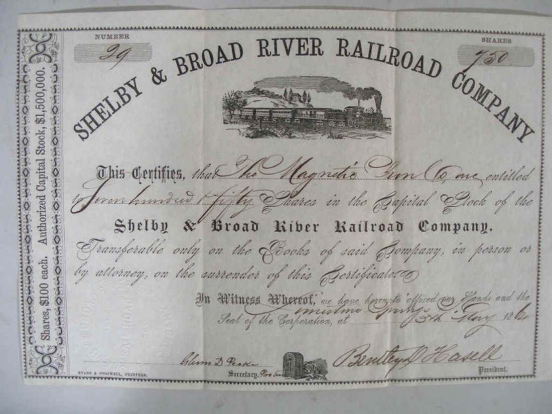
Shelby & Broad
River RR |
|
The road was chartered in both North and South Carolina in
December, 1862, with plans to commence grading immediately to
the Magnetic Iron Works, on the Broad River. The likely route to be taken
is detailed in
NP, CM
2-14-63. This route would have required 75 miles of new
track, far beyond what the South could furnish, without counting
the labor and supplies required. Shelby would have no railroad connection until 1874. The President for 1863 and 1864 was Bentley D. Hasell. Directors are named in the May, 1863
and May, 1864 articles. A. C. McGillivray was the Secretary in
1863. |
| NP, CW 3-5-61 |
|
NP, CM
11-19-62 |
|
B33, S&BR 12-18-62 |
|
NP,
CM 2-14-63 |
|
NP,
CM 2-23-63 |
| NP, WD 2-24B-63 |
|
NP,
CM 2-25-63 |
|
NP,
CM 3-12A-63 |
| NP, YE 3-25A-63 |
| NP, YE 4-29-63 |
|
NP, CM
5-7-63 |
| NA,
RR 5-13-63 |
| NP, YE 5-13-63 |
| NP, GP 5-14-63 |
| NP, WD 5-19-63 |
| NP, GP 5-21A-63 |
|
NP, SC
9-3-63 |
| SCA, C&C 11-30-63 |
|
NP, CM
1-11-64 |
|
NP, CM
2-27-64 |
|
NP,
CM 2-27B-64 |
| NP, SC 3-1-64 |
|
NP, CM
4-18-64 |
|
NP, CM
5-20A-64 |
| Shelby
& Broad River RR Stock |
| NP, SC 11-16-64 |
|
LVA,
RRB 12-13-64 |
|
|
South Carolina
Central RR |
| The April 1861 Annual Report of the
Northeastern RR reports that this road had been
chartered; the Northeastern pledged $145,000, on certain
conditions. The road was to run from Charlotte, N. C. to
a point on the Northeastern road (and then on to
Charleston). The proposed route
(145 miles long) was through Lancaster, Bishopville,
Sumter and Manning, to Gourdin's station, 50 miles
northeast of Charleston. It is unlikely any work was
done. |
|
NP, LL 1-2-61 |
|
NP,
LL 2-27-61 |
|
NP, LL 2-27A-61 |
|
NP,
LL 3-27-61 |
|
NP,
LL 4-3-61 |
|
NP,
LL 4-3A-61 |
|
NP,
LL 4-3B-61 |
|
NP,
LL 4-10-61 |
|
NP,
LL 4-17-61 |
| NP, CC 4-20-61 |
|
| Barnwell RR |
This 10-mile long road would eventually connect Barnwell with
the South Carolina RR at Blackville. W. H. Duncan was President
in 1861 and Mr. Walker was in 1862; over one hundred hands were
employed in May of 1862, under Henry Stevens Haines, Engineer.
|
| Florence to
Fayetteville, N. C. |
See the North Carolina entry for this road
|
|
Tennessee |
|
Sequatchie Valley RR |
| This 13-mile feeder line of the Nashville &
Chattanooga RR was chartered in 1860 and mostly graded in the summer of 1861. It is
unknown if any iron was laid down, though grading was probably
completed. Its route was from Bridgeport to Jasper. |
| AR, N&C 7-1-61 E |
| NP, ASCY 2-8-63 |
|
|
Texas |
|
Houston, Trinity & Tyler RR |
| This road was chartered in 1860 to build from
a connection with the Galveston, Houston & Henderson
Railroad, at Houston, to Tyler; by way of the Southern Pacific
RR, it would have reached water transportation at Jefferson,
on Caddo Lake. In November 1860 twenty miles of track was
under contract and twelve miles of rail was said to be in
Galveston. At least 2 miles had been graded by June of
1861 and a load of rails arrived in January of the
same year. The company acquired a few freight cars; they and
the rails were later sold to the Galveston & Houston
Junction RR. The road would have been about 200 miles long. In
1860, the President was Capt. Joseph J. Hendley; Vice-President,
Loranzp Sherwood; Directors, Gen. E. B. Nichols, James Sorley,
A. B. Lufkin, John L. Darragh, Thad Mather, George Ball, Henry
N. Jones, J. A. Thompson and Benjamin L. Goodman. |
| NP, GDC 1-4-61 |
| NP, GDC 1-4A-61 |
| NP, GN 1-12A-61 |
|
NP,
DP 1-22-61 |
| NP, GN 1-22-61 |
| NP, GTN 2-5B-61 |
| NP, HT 2-12B-61 |
| NP, GTN 2-19-61 |
| NP, HT 4-9A-61 |
| NP, MRT 6-8-61 |
|
NP,
TR 6-8-61 |
|
TX, GH&H 9-1-61 |
|
NA,
HT&T 6-30-62 |
|
NA,
HT&T 7-31-62 |
|
NA,
HT&T 8-30-62 |
|
NA,
HT&T 12-18-62 |
|
NA,
HT&T 12-31-62 |
|
NA,
HT&T 2-28-63 |
|
NA,
HT&T 3-24-63 |
|
NA,
HT&T 3-31-63 |
|
NA,
HT&T 6-3-63 |
|
NA, DT
6-21-63 |
|
|
Indianola RR |
| This 16-mile long road was chartered in 1858
to build from Indianola to Clark Station on the San Antonio
& Mexican Gulf RR. The road was graded and ties were on
hand when the war started. Negotiations were being made for
the purchase of the rails in July, 1860. No track appears to have been
laid and the Road owned no rolling stock. The ties were burned in December 1862. In 1860, the
President was Henry Runge, the Treasurer was A. ??chel and the Directors were Henry
Runge,
William H. Woodward, John E. Garey, H. J. Huck, John H. Dale
and David C. Proctor. In 1861, the Treasurer was William T.
Yancy and Acting Superintendent was Dudley Schultz. |
|
TX, I 11-1-61 |
| NP, MAP 9-26-61 |
| NP, MAP 10-3-61 |
| OR Series 1, Vol. 15, Page 909 |
|
|
Columbus, San Antonio & Rio Grande RR |
| This road was intended to connect with the
Buffalo Bayou, Brazos and Colorado RR and head west, going
through Gonzales and San Antonio to the Rio Grande River. It
was chartered in 1858, and, with the slow-down caused by the
war, was required to commence work by
early 1863 and complete fifty miles every two years
thereafter. It is highly unlikely that any work was done
during the road. The start of the
survey of route was announced in late 1860, so it is very
unlikely that any work was done before the war started. Bentley D.
Hasell, Chief Engineer and Superintendent of the
New Orleans, Jackson & Great Northern RR was reported to
be the Chief Engineer of the new road. |
| NP, GTN 2-19-61 |
|
|
Austin & Brenham Air Line RR |
| This road was chartered in 1860. It was to
depart Brenham, building out from the Washington County RR, to
Austin. It was required to commence work by
July 1861 and complete twenty-five miles of the road by
December 30, 1863, or forfeit their charter. Some grading was done, but it is very unlikely that any meaningful
work was completed during the war. President was John R. Banks
and H. H. Hayne, secretary. |
| Washington County Railroad Map |
| NP, SG 1-12A-61 |
| NP, HT 2-12B-61 |
| NP, GTN 2-19-61 |
| NP, SG 2-23-61 |
|
NP, TD
3-6-61 |
| NP, SG 3-16-61 |
| NP, HT 5-14-61 |
|
|
Virginia |
| Keysville, Va. to Clarksville,
Va. |
| The Roanoke Valley Railroad
was so poor that it recognized that to survive, it needed to
connect to the Richmond & Danville Railroad and become
part of a through route. When war came, it saw itself as a
vital, incomplete route around the dangerous area around
Petersburg and Norfolk. General Lee was convinced of the value
of the short (30-mile), easy extension that was already under
construction (3 miles of track had been laid and much grading
completed) and promoted it. Unfortunately for the Roanoke
Valley RR, their roadbed and track were in such poor condition
that their road would need to be rebuilt along with the
extension. This extra work, and the minimal improvement in the
supply situation that the new route would provide, caused the
project to be dropped. It was unrealistically resurrected
in the very last days of the war. |
| OR Series 1, Vol. 2, Page 830 |
|
NP, REX 12-10A-61 |
|
NP, REX 12-13D-61 |
| OR Series 4, Vol. 1, Page 1022 |
| OR Series 4, Vol. 1, Page 1025 |
| OR Series 4, Vol. 1, Page 1085 |
|
VAA,
RV 5-14-62 |
|
NA, SWR
12-1-62 |
|
NA,
ENGR 10-19-64 |
| NP, RD 1-13-65 |
|
NA,
QMR 1-30A-65 |
| NP, RD 2-21-65 |
| NP, RD 2-24-65 |
|
| Jackson's
River, Va. to Covington, Va.
(Virginia Central Railroad) |
| This 9-mile extension of
the Virginia Central Railroad had been long planned, the route
was graded, and the iron was on hand. That railroad, however,
expected to have to use this rail to maintain its road, due to
the heavy demands being made on it. The road wanted the
Confederate Government to provide iron from the Baltimore
& Ohio Railroad or some other source for this extension.
The extension was to help bring in crops and to help supply
the army operating to defend western Virginia (later West
Virginia). Though the extension was deemed important, the rail
was not provided. The idea was resurrected in late 1863.
|
|
NA, QMR
9-27-61 |
|
NA, QMR
10-2-61 |
| NA, QM 10-3A-61 |
|
BA, RR
12-14-61 |
|
NA,
QMR 1-25C-62 |
|
NP,
REX 2-7D-62 |
| NP, RD 2-10B-62 |
| OR Series 4, Vol. 1, Page 944 |
| OR Series 1, Vol. 29, Part 1, Page 946 |
| NA, ENG 2-25B-64 |
|
| Covington,
Va. to White Sulphur Springs, Va. (West Va.) |
| This 21-mile
section of the Covington & Ohio RR was under construction
before the war. Its value to the Confederacy was in its
ability to better support Confederate troops operating in
Western Virginia. The road depended on the completion of the
Virginia Central RR's section between Jackson's River and
Covington, provision of iron rails by the Confederate
Government, and Confederate troops to operate in Western
Virginia. Since none of these conditions were met,
construction was not continued.
The road was not incorporated before the war and was being
constructed by the Virginia Board of Public Works. Its
Chief Engineer was Charles B. Fisk. A proposal to
complete the entire Covington & Ohio RR {an addition of
some 160 miles beyond the 21 from Covington to White
Sulphur Springs) was advanced in Congress in early 1864,
but had no prospect for making any construction progress
before the end of the war. |
| NP, RD 1-14-61 |
| NP, RD 2-5-61 |
| NP, AG 4-2A-61 |
| NP, RD 5-4A-61 |
| NP, RD 5-29-61 |
| NP, RD 6-18E-61 |
|
AR, C&O 9-1-61 E |
| NP, RD 12-11-61 |
|
BA, RR
12-14-61 |
| NA, G 12-17-61 |
| NP, RD 2-4-62 |
| NP, RD 2-6-62 |
|
NP,
REX 2-7A-62 |
| NP, WJ 2-17-62 |
|
NP,
RW 2-18-64 |
|
| In Richmond, Va. |
| A Virginia law, enacted February 1, 1862,
allowed the Richmond, Fredericksburg & Potomac RR and the
Richmond & Petersburg RR to construct their own connection
within the city. This connection was later deemed to be
useless because of the heavy grade.
|
| NP, RD
6-25-61
|
| LVA, RF&P 7-26-61
|
| LVA, RF&P 8-7-61
|
|
NP, REX 12-17-61 |
|
NP, REX 12-20-61 |
| AR, R&P 2-1-62
|
| NA, ENG
6-24-64
|
|
NP,
REX 2-4-62 |
|
| In Petersburg, Va. |
|
| Richmond, Fredericksburg &
Potomac RR
to the Orange & Alexandria RR and the Manassas
Gap RR |
| This connection of
about 38 miles was designed to provide another rail line from
central to northern Virginia to support the army in that area.
The connection was authorized by the Virginia General Assembly
in mid-February of 1862. Before construction could begin, the
army left the area to return to Richmond to confront the Union
army advancing up the Peninsula. A three mile branch was
intended to run from the main RR to the batteries at
Evansport (now Quantico). |
|
NP, REX 12-13E-61 |
|
BA, RR
12-14-61 |
| LVA, RF&P 12-24-61 |
|
NP,
REX 1-21-62 |
| NP, RSTD 1-29B-62 |
|
NP,
REX 2-14-62 |
| LVA, RF&P 2-15-62 |
| NP, RD 2-17-62 |
|
NP, REX 2-18A-62 |
| AR, RF&P 2-19-62 |
|
VAA,
RR 2-19-62 |
| LVA, RF&P 3-7-62 |
|
LVA, RF&P 4-30-62 |
|
| Saltville,
Va. |
| The demand for salt from the
Saltville, Va. works prompted such expansion of the works and
its operations that the Virginia & Tennessee RR tracks at
the works were frequently jammed with trains. Also, the
increased operations required that wood be brought several
miles by wagon to keep the kettles going. A 4-mile extension
of the track was constructed to ease both problems. |
| NA, ENG 5-7-63 |
| NA, ENG 5-9-63 |
|
| Richmond Coal Fields
to the Richmond & York River RR |
|
This 19-mile road had been under discussion by the railroad for
several years. The road from the pits to Hungary Station on the
Richmond, Fredericksburg & Potomac RR had been built by the
owners of the pits and the intention for some time had been to
continue the existing road over to the Richmond & York River
RR. This appears to have been a formal step in creating that
feeder road. |
| NP, RD 3-25-61 |
|
|
Strasburg to
Winchester, Va.
|
|
This 18-mile extension of the
Winchester & Potomac RR to support troops in the Winchester (Lower
Shenandoah Valley) area was passed by the
Virginia Legislature only days before Jackson had to fall back
from Winchester to near Strasburg. Despite Jackson's victories
in the area, the proposal was never again considered. To
make the idea palatable to the Alexandria, Va. interests, the
road would be under the control of the Manassas Gap RR, which it
would meet at Strasburg. The iron would have been
"donated" by the Baltimore & Ohio RR. |
| NP, WR 2-22-61 |
| NP, AG 2-26-61 |
| NP, AG 3-20-61 |
| NP, WR 3-22-61 |
| NP, AG 4-2-61 |
|
NP,
AG 4-15-61 |
| NP, WR 4-26-61 |
| NP, AG 4-29-61 |
| NP, AG 5-9-61 |
| NP, RD
6-19B-61 |
|
NA, QMR
8-21-61 |
| OR Series 1, Vol. 51, Part 2, Page 248 |
| NA, W&P 8-29-61 |
| NA,
W&P 9-1-61 |
|
NA,
QMR 9-10B-61 |
| NP, NYT 9-27-61 |
| NP, NR 10-11-61 |
| NP, LN 12-19-61 |
| NP, WR 1-3-62 |
| NP, LN 1-14-62 |
| NP, WR 1-31-62 |
|
NP,
REX 2-7C-62 |
| NP, RD
2-10C-62 |
| NP, WR 2-14-62 |
|
NP,
REX 2-18-62 |
|
VAA,
RR 2-21-62 |
| NP, RD 2-22-62 |
| OR Series 1, Vol. 43, Part 2, Page 925 |
|
|
Virginia & Kentucky RR
|
A newspaper report from late 1860 reports that work has been
commenced at Bristol. Contracts have been let from that place to
Estillville, Scott County, Va. It was anticipated that 3,000
hands would be at work on the road by early spring, 1861. It is
unlikely an meaningful work was completed.
|
|
Danville to Virginia & Tennessee RR
|
| This 80-mile road would have been the
extension of the Danville to Company Shops road to
enable the movement of Deep River coal from central
North Carolina into eastern Tennessee and northern
Georgia. There is no indication any work was done. |
| NP, FO 1-17A-61 |
|
|
|