|
The Confederate Government constructed
several short stretches of track to meet needs that were not of
interest to commercial railroads. Very few details have come to
light on these projects.
|
|
Connection |
Status |
|
Alabama |
|
Montgomery, Al.
|
| The Railroad Bureau paid for a short line
(about 2 miles long) built in Montgomery to connect
the Montgomery & West Point and Alabama &
Florida (of Alabama) Railroads. Looking at a map makes
it clear that at no extra effort, the Montgomery &
Eufaula RR was probably also connected by the same line {Ref:
Official Atlas 74/3}. It was constructed in early
September 1863. It was improved by the Bureau in
February 1864 (lowering the grade), using the Montgomery
& Eufaula Railroad's workforce under contract. It is
unclear whether rail was laid before the arrival of
three car loads in April, 1864. |
|
AL, A&F 12-3-61 |
| NA,
SWR 12-4A-61 |
| NA,
SWR 12-5-61 |
|
NA,
QMR 12-16-61 |
|
NA, RR
3-22A-63 |
| NA, A&F
4-8-63 |
|
NA, ENG
4-30-63 |
|
AHC,
LPG 5-11-63 |
|
NA,
ENGR 5-11-63 |
|
AHC,
LPG 5-15-63 |
| NA, ENG 5-23-63 |
|
NA, QMR
8-12-63 |
| NA,
QM 8-27-63 |
| RRBAT 9-14-1863 |
| NA, M&E 11-20-63 |
|
NA, QMR
12-3-63 |
|
NA, QMR
1-27-64 |
| NA, M&E 2-5-64 |
| NA,
M&E 2-5A-64 |
| NA,
RRBT 2-9A-64 |
| NA, M&E 2-10-64 |
| NA, M&E 2-10A-64 |
|
NA, M&WP 4-15-64 |
|
NA, QMR
8-16-64 |
| NA,
RRB 8-22C-64 |
|
LVA,
RRB 12-9-64 |
|
NA,
RRB 12-31L-64 |
| AR, A&F(FL) 5-1-67 S |
|
|
Montgomery, Ala.
|
In 1865, Sims reports buying a locomotive for the track from
Montgomery to the river.
|
|
Montgomery, Ala.
|
I'm not sure what line this supported.
|
|
Selma, Ala.
|
|
|
Tennessee River
|
This one-mile long siding was
constructed by the Nashville & Chattanooga RR under the
orders of Gen. Sam Jones in later 1862 to assist in moving
trains over the river. It was probably at Bridgeport, Ala.
|
|
Bibb Iron Works RR
|
In 1863, the Confederate Government
bought controlling or total control of the Bibb Iron Works. The
Works were enlarged and a rolling mill added. According to the
article below, a 2 1/2 mile railroad was built to connect the
Works to the Alabama & Tennessee River RR.
|
|
|
|
Arkansas |
|
|
|
Florida |
|
|
|
Georgia |
|
Augusta, Ga.
|
| In 1863, Col. Wadley reported turning
over to Capt. Sims railroad iron that had been laid in
Augusta. This was 69 tons to connect the 600 yards
between the Augusta & Savannah RR to the Georgia RR and
thereby to the South Carolina RR -- a move recommended
by Ashe in 1861. A direct connection between the South
Carolina RR and the Augusta & Savannah RR may have been
built in late 1864. |
| NP, MT 11-15-61 |
| NA, G 12-17-61 |
| B3, LEE 2-22-62 |
| SC, QM 3-18-62 |
| UG, RR 4-3-62 |
| OR Series 1, Vol. 6, Page 428 |
| OR Series 1, Vol. 6, Page 471 |
| UG, RR 4-19-62 |
| OR Series 1, Vol. 14, Page 482 |
|
NA, QMR
2-7C-63 |
| NA, AG 5-27-63 |
| NA,
RRB 7-31D-63 |
| NA,
RRB 9-1F-63 |
| NA, CoG 10-17-63 |
| NA, CoG 10-17A-63 |
| NA, RRB
12-31-64 |
|
|
Macon, Ga.
|
An 800-yard spur was approved by the Macon city government,
connecting the Macon & Western RR to the old Macon & Western
RR shops, where the Macon Armory was being set up. A new
Armory was being built alongside the Macon & Western RR,
about 2 miles from city center (the one shown on the
Official Records Atlas map). This new facility was not yet
completed at the end of the war. I have found no proof that
the approved spur was constructed, but since the money,
rails and permission were all in place, it probably was
built by the Macon & Western RR. The
rail was flat rail, provided by the CS Navy at Columbus, at 30
lbs per yard weight.
|
NA, MA
7-17-62 |
|
NA, MA
7-22-62 |
|
NA, MA
8-6-62 |
|
NA, MA
8-11-62 |
| NA,
RR 8-20-62 |
|
NA, MA
8-26-62 |
|
NA, MA
8-29-62 |
|
NA, MA
9-4-62 |
| NA,
RR 9-22-62 |
|
NA, MA
9-24-62 |
|
NA, MA
9-29-62 |
|
NA, MA
10-4A-62 |
|
NA, MA
10-6-62 |
|
NA, MA
1-10-63 |
|
|
Macon, Ga. |
The Superintendent of the CS Laboratory in Macon asked
permission and help of the Macon & Western RR to build a
short siding on the grounds of the Laboratory. The ties
ordered would have laid 1 1/2 miles of track.
|
|
Savannah, Ga.
|
| This 1,400 yard long connection
between the Central (of Georgia) RR and the Savannah, Albany
& Gulf RR, at Savannah, was recommended to Congress in
December of 1861 and was completed in early June of 1862. |
| NA, G 12-17-61 |
|
NA,
DSCG 4-28A-62 |
|
NA,
DSCG 5-13-62 |
| NP, MT 6-6-62 |
| NA,
RR 6-10-62 |
| NA,
RR 6-10A-62 |
| NA,
RR 6-11-62 |
|
NP,
SR 6-2A-63 |
|
NP, SMN 9-15A-63 |
|
|
Savannah, Ga.
|
A 3 1/4 mile connection was laid from the city to Fort Jackson. It
appears that a track was laid in late 1863 and was
improved and partly placed on a trestle at that time.
Connection in the city was made to the Savannah, Albany
& Gulf RR. It appears to have had its own locomotive in
early 1864.
| NA,
RR 8-31-63 |
|
NP, SMN 9-15A-63 |
| NA,
RR 10-7-63 |
| NA,
RR 10-14-63 |
| NA,
RR 10-31-63 |
| NA,
RR 10-31A-63 |
| NA,
RR 10-31F-63 |
| NA,
RR 11-6-63 |
|
NA,
DSCGF 11-7A-63 |
| NA,
RR 11-7-63 |
| NA,
RR 11-23A-63 |
| NA,
RR 11-30-63 |
| NA,
RR 11-30A-63 |
| NA,
RR 11-30B-63 |
| NA,
RR 12-3-63 |
| NA,
RR 12-3A-63 |
| NA,
RR 12-16-63 |
| NA,
RR 12-24-63 |
| NA,
RR 12-31-63 |
| NA,
RR 12-31D-63 |
|
NA,
ENGR 1-18-64 |
| NA,
RR 1-31-64 |
| NA,
RR 1-31B-64 |
| NA,
RR 1-31C-64 |
| NA,
RR 2-1-64 |
|
NA, CoG
2-8-64 |
|
NA, CoG
2-20-64 |
| NA,
RR 2-23-64 |
| NA,
RR 2-28-64 |
| NA,
RR 2-29C-64 |
|
NA,
A&G 3-11-64 |
| NA,
RR 4-7A-64 |
|
AR, A&G 1-1-66 P |
|
|
Savannah, Ga.
|
A short track was ordered constructed from the Atlantic &
Gulf RR line to the flour and grist mills in eastern Savannah.
|
|
Columbus, Ga. |
The Mobile & Girard RR and the Muscogee RR appear to have been
connected in 1863.
|
|
Abbeville, S. C. to Washington, Ga. |
On March 15, 1865, Beauregard ordered Engineer Major McCrady
to connect the Charlotte & South Carolina RR to the Georgia
RR by way of the Greenville & Columbia RR and new track from
Abbeville to Washington. The new track would have been about
45 miles long and would have required a ferry or bridge over
the Savannah River. There is no indication any work was done
on this new route.
|
|
|
|
Louisiana |
|
New Orleans, La.
|
|
|
New Orleans, La.
|
This was probably a spur from the New Orleans & Carrollton
RR to the magazine. The road was about 2/3 mile long.
|
|
Shreveport, La. to Marshall, Tex. |
See Texas entries
|
|
|
|
Mississippi |
|
Corinth, Miss. |
A temporary track is mentioned, but there is no
further information.
|
|
|
|
North Carolina |
|
Fayetteville, N. C.
|
| A road of about 1.5 miles was planned to link
the arsenal to the Western RR (to get coal) and the Cape Fear
River (for connection with Wilmington and its railroads). |
| NP, RD 2-7-62 |
| NA,
RR 2-28-62 |
|
|
Wilmington, N. C. |
A RR bridge to cross the Cape Fear River was under study.
|
|
Goldsboro, N. C. |
A spur of about 175 yards was built to connect the Piedmont
and North Carolina RRs to a QM warehouse
|
|
Halifax, N. C. |
The Navy requested a 3/4 mile spur to the local Navy yard.
Results of the request are unknown
|
|
|
|
South Carolina |
|
Charleston,
S. C.
|
| A connection was made between the Charleston
& Savannah RR and the South Carolina RR by building a
bridge over the Ashley River. The bridge was constructed on
private property, using State of South Carolina money. The
private owner refused to allow any but government freight and
passengers to use the bridge. It was completed the first week
of April, 1863. In 1864, the company tried to get
government assistance in building a permanent bridge, but was unsuccessful.
A connection was also required in the City itself to connect
the Charleston & Savannah RR and the South Carolina RR. |
| NP, CM 11-18-61 |
| OR Series 1, Vol. 6, Page 407 |
|
SC, QM
3-18-62 |
|
NA,
DSCG 3-27-62 |
|
NA,
DSCG 4-2-62 |
|
NA,
DSCG 4-16-62 |
|
NA,
DSCG 4-18-62 |
|
NA,
DSCG 4-21-62 |
|
NA,
DSCG 4-23-62 |
|
NA,
DSCG 4-23A-62 |
|
NA,
DSCG 4-26-62 |
|
NA,
DSCG 4-28-62 |
| OR Series 1, Vol. 14, Page 573 |
|
NA, DSCGF
1-27-63 |
|
NA, DSCGF
1-27A-63 |
|
SC, C&S 1-30-63 |
| COC, C&S 3-14-63 |
|
NA, DSCGF
3-14-63 |
|
NA, C&S
7-31-63 |
|
NA,
QMR 9-12B-63 |
| NA, ENG 10-14B-63 |
|
NA,
DSCGF 11-11-63 |
| NA, ENG 12-18-63 |
| NA,
ENG 12-18A-63 |
|
NA,
ENGR 1-9-64 |
|
NA, QMR
1-9A-64 |
| NA, ENG 1-23-64 |
|
NA,
ENGR 1-26-64 |
|
NA,
QMR 2-13A-64 |
| NA, NE
2-19-64 |
| NA, ENG 2-22I-64 |
|
NA,
ENGR 2-25-64 |
| NA, ENG 3-1B-64 |
|
NA,
DSCGF 3-8-64 |
|
NA,
ENGR 3-8-64 |
| NA, ENG 3-16-64 |
|
NA,
ENGR 3-20-64 |
|
NA,
ENGR 3-22A-64 |
| NA, ENG 3-26-64 |
| NA, ENG 3-26B-64 |
| NA, ENG 3-28B-64 |
| NA, ENG 3-28E-64 |
|
NA,
DSCGF 4-23-64 |
|
NA,
QMR 4-23C-64 |
| NA, ENG 5-2B-64 |
|
NA,
DSCGF 5-3-64 |
|
NA,
DSCGF 5-18-64 |
| NA, ENG 5-19D-64 |
|
|
|
|
Tennessee |
|
Nashville, Tenn.
|
| A report to the State
Assembly says that money was advanced by the State to connect
3 railroads in the city, with the Memphis, Clarksville &
Louisville RR doing the majority of the work. A newspaper report confirms the
completion of the connection.
|
| NP, RD 9-28A-61 |
| OR Series 1, Vol. 52, Part 2, Page 158 |
|
|
Memphis, Tenn.
|
| These two short roads were to connect
the city's three roads so that troops and supplies could
be moved through the city without delay. It was also to
help evacuate the city, if required. The Memphis & Ohio
RR to Memphis & Charleston RR was 0.9 miles and the
Mississippi & Tennessee RR to Memphis & Ohio RR was 1.7
miles. The Ohio-Tennessee roads connection went down
Main Street to prevent the need for significant grading.
Both connections were temporary but were still shown on a
Union map of the city, made in the spring of 1865. |
|
NP, MAP 1-11B-62 |
| NP, MAP 2-23-62 |
| NP, MAP 2-28-62 |
| NP, MAP 3-4-62 |
| NP, MAP 3-8-62 |
| NP, MAP 3-9-62 |
| NP, MAP 3-14-62 |
| NP, MAP 3-15B-62 |
| NP, MAP 3-19-62 |
| NA,
Mem&O 3-x-62 |
| NP, MAP 4-12-62 |
| NP, MAP 4-22-62 |
| NP, RD
5-8A-62 |
| NA,
QMR 1-5-64 |
|
|
|
|
Texas |
|
Galveston, Tx.
|
| A 5.6 mile extension to the
Galveston, Houston & Henderson RR (then under control of
the CS Government) was built (in early 1863) to support the
gun batteries / forts on southern and eastern Galveston Island.
It is shown on Confederate maps in the Atlas to Accompany the
Official Records. |
| Galveston Railroads |
| NA,
RR 2-4-63 |
| NP, HT 4-3A-63 |
| NA,
GH&H 4-30-63 |
| OR Series 1, Vol. 15, Page 1063 |
| NA,
RR 5-1-63 |
| NA,
GH&H 5-12-63 |
| NA,
RR 5-24-63 |
| NA,
GH&H 6-30-63 |
| NP, RSJ 11-6-63 |
|
NA, DT
3-3-65 |
|
NA, DT
4-13-65 |
|
|
Marshall, Tx. to Shreveport, La.
Shreveport & Marshall RR |
| The 14 miles of the Southern
Pacific RR from Jonesville, Tx. to Swanson's Landing (on Caddo
Lake) were removed in 1864 and re-laid from Jonesville to
Wascom, Tx. (on the Louisiana border). The first 5 miles west
of Shreveport was operating as part of the Vicksburg,
Shreveport & Texas RR. It appears that the
remaining 8 or so miles were laid with rails
from the Red River RR. Post-war
statements from the officers of the Southern Pacific RR
say that the road was completed in 1864 and was
operating, though the report to stockholders says the
road was only completed in June, 1866. |
| Though the facts are unclear, it appears that the
Shreveport & Marshall RR was chartered shortly before
the war to ensure the timely completion of the road over
that route to ensure the cotton crop from that area got
to market. The road appears to have leased the route
from one city to another for 25 years, then built the
road over that route. The road appears to have not been
operational during the war, though some work was done.
The road is listed as a Military Road because of the
actions of the military in relocating and pushing the
Southern Pacific RR. |
|
|
Houston, Tex.
|
A 1,600-foot connection was made
between the Texas & New Orleans RR and the Houston &
Texas Central RR in November of 1863.
|
NA, G&HJ 12-14-61 |
|
NA,
DETX 9-8-63 |
|
NA, RR
9-8F-63 |
|
NA, H&TC 9-18-63 |
|
NA, H&TC 9-21-63 |
|
NA,
DTNMA 11-12-63 |
| NA,
RRB 11-12-63 |
|
NP,
HT 11-20-63 |
| NA,
RRB 11-23-63 |
| NP, SG 11-23-63 |
| NA,
T&NO 1-8-64 |
|
NP,
HT 8-30-65 |
|
|
Houston, Tex. (the
Galveston
&_Houston Junction RR) |
A 2-mile road to connect the
Galveston, Houston & Henderson RR to the Houston & Texas Central
RR and into the city of Houston. The rail was purchased from the
Houston, Trinity & Tyler RR. The road was authorized by the
Legislature in mid-1861, but construction had not started by the
end of the year. The road required two bridges which were not
completed until October, 1865. It is not known if the road
actually functioned. V. M. Brown was President; James Converse
was Chief Engineer in 1863 and W. E. Wood was Chief Engineer and
Superintendent later in that year. |
|
|
|
Virginia |
|
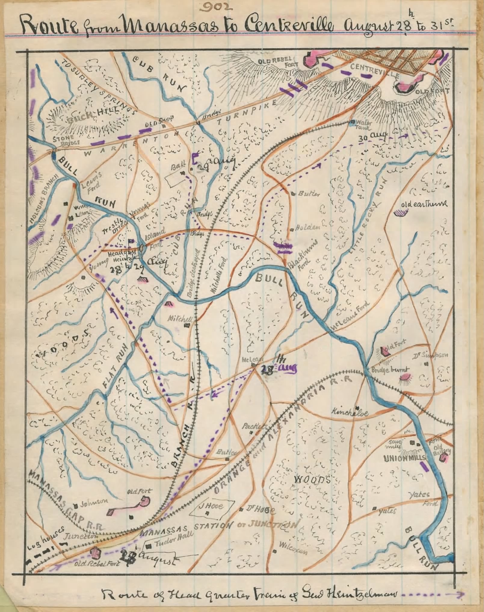
Centreville, Va.
|
| This 5-mile road was
completed by Capt. Thomas Sharp
in early 1862 to ease the supply situation of the army in the
Manassas area. General Johnston had selected a winter
encampment that was almost impossible to supply by wagon
during the winter rains. This railroad, running from Manassas,
on the Orange & Alexandria RR, to the
camp, replaced the reliance on the wagon road. The railroad was
poorly and hastily constructed, using too few ties under the
Baltimore & Ohio RR rail; it remained in operation only
about a month before Johnston evacuated the area to pull back toward
Richmond. |
| Centreville RR
Map |
| Manassas Junction Railroads |
| AR, O&A 9-30-61 EC |
|
NA,
QMR 10-24-61 |
|
NA, QM
10-26A-61 |
|
NA, QMR
11-3-61 |
| NP, RD 11-19C-61 |
|
NA, QM
11-20-61 |
| NP, YE 12-5-61 |
| NP, RSTD 12-11-61 |
| NP, LN 12-13-61 |
| NP, RD 12-14-61 |
|
NP,
MAP 1-10-62 |
|
NP, CLC 1-17-62 |
| NA,
MG 1-31A-62 |
| NA, MG 2-3-62 |
|
NP,
CM 2-12D-62 |
|
NA, RF&P
2-24-62 |
|
NP,
REX 2-28-62 |
| NA, MG 3-1-62 |
| NA,
RRB 3-5-62 |
|
NA, RRB
3-9C-62 |
|
VHS,
RR 3-18-62 |
| NP, NOTP 4-1-62 |
| NA,
RRB 4-30P-62 |
| Biography of Thomas R. Sharp |
| Did Sharp Build the Centreville Railroad? |
|
|
Petersburg, Va.
|
| This short line (approximately 1 1/2 mile long) connected
all of the railroad depots inside the Petersburg city limits,
though for most of the war its main use was connecting
the Richmond & Petersburg RR to the Petersburg RR. It must have originally be built of light rail
(probably strap), since only very light locomotives were
allowed on it (14 ton locomotives). Originally, only in extreme situations were freight trains
allowed to use this line. The road was reconstructed in May,
1862. A RR bridge was constructed over the
Appomattox River in August, 1863.
|
| AR, R&P 4-1-61 P
|
| NP, RD 4-27-61
|
| NP, RD 5-1-61
|
| NP, RD 5-2-61
|
| NP, AG 5-4-61
|
| NA, QM 6-6-61
|
|
NA, QMR
6-11-61 |
|
NP, REX 6-25A-61 |
| OR Series 4, Vol. 1, Page 405
|
|
NP,
REX 6-28-61 |
|
NP, REX 6-28A-61 |
| OR Series 4, Vol. 1, Page 417
|
| OR Series 4, Vol. 1, Page 484
|
| NP, RD 8-15-61
|
| LVA, R&P 10-11-61
|
| LVA, R&P 10-15A-61
|
| LVA, R&P 10-20-61
|
| LVA, TRED 11-18A-61
|
|
NA,
QMR 11-26B-61 |
|
NA, QM
11-27-61 |
|
NA, QM
11-27C-61 |
|
NA, QM
11-27D-61 |
| AR, R&P 2-1-62
|
| NP, RD 2-3A-62
|
|
NA, RR
4-7A-62 |
|
NA, RRB
4-12-62 |
| NA,
RRB 4-15A-62
|
|
NA, RRB
4-16-62 |
|
NA,
QMR 4-24B-62 |
|
NA,
QMSW 5-8-62 |
| NA,
MG 5-19-62
|
|
NA,
RRB 5-22B-62 |
| NA, RF&P
6-30-62
|
| NA,
RRB 6-30F-62
|
| NA, VC
6-30-62
|
| NA,
RRB 7-18-62
|
| NA,
RRB 7-18A-62
|
| NA,
RRB 7-21-62
|
| NA, VC
7-24-62
|
| NA,
RRB 9-1-62
|
| NA,
RRB 9-5-62
|
| NA,
RRB 9-5A-62
|
| NA,
RRB 9-17-62
|
| NA,
RRB 9-17A-62
|
| NA,
RRB 9-29-62
|
| NA,
RRB 9-29A-62
|
| NP, RD 2-5-63
|
| NA, QM 5-9-63
|
|
NA,
QMR 5-15B-63 |
|
NA, QMR
5-26-63 |
|
NA,
QMSW 5-26-63 |
|
NA, QMR
5-28-63 |
|
NA,
QMR 5-28A-63 |
| NA, ENG 6-4-63
|
|
NA,
ENG 6-26A-63 |
|
NA,
ENGR 6-26-63 |
|
NA, QMR
6-29-63 |
|
NA,
ENGR 6-30A-63 |
| NA, ENG 7-3A-63
|
| NA, ENG 7-4-63
|
| NA,
RR 7-29A-63
|
| NA, RF&P
8-1-63
|
| NP, RS 8-10-63
|
|
NA,
ENGR 8-11-63 |
| NA, ENG 8-13-63
|
|
NA,
QMR 8-17B-63 |
| NA,
RRB 9-1B-63
|
|
NA, QM
9-4-63 |
| NA,
RR 9-4-63
|
| NA,
RR 9-8E-63
|
| NA,
RR 9-15-63
|
| NA,
RR 9-15K-63
|
|
NA, RR
10-3A-63 |
| NA,
RR 10-5-63
|
| NA, QM 10-14A-63
|
|
NA,
QMR 11-14A-63 |
|
NA,
QMR 11-14B-63 |
|
NA,
QMR 11-15A-63 |
|
NA,
QMR 11-21-63 |
|
NA,
QMR 12-5B-63 |
| RRBA 12-5-1863
|
|
NA,
QMR 12-10B-63 |
| NA, RF&P
1-1-64
|
|
NA, QMR
1-23-64 |
|
NA,
QMR 1-23B-64 |
| NA,
RF&P 1-23-64
|
| NA,
R&P 1-30-64
|
| NA,
RRB 2-3-64
|
| NA,
RRB 2-15-64
|
| NA, RF&P
3-1-64
|
| NA, RF&P
5-1-64
|
| NA, RF&P
8-1-64
|
|
NA,
ENGR 9-19A-64 |
|
NA,
ENGR 9-19B-64 |
| AR, R&P 10-1-65 P
|
| A map prepared by the Confederate Engineer Bureau and the
Engineer Officer in charge of the Petersburg defenses in 1863
shows all five of the railroads that entered the city
connected at various points near the city center. {Ref:
Official Atlas 40/1} I assume these officers would not
make an error about such a fact, but I have no other
information on the connections. See Confederate Railroad Construction Plans
|
|
|
Richmond, Va.
|
| The possibility of rolling stock being trapped
north of Richmond if the city fell caused the Government to
lay a temporary track on the streets of the city to allow the
evacuation of rolling stock south. The track was evidently
never used for commercial traffic. The 1/2 mile line connected
the Richmond, Fredericksburg & Potomac RR with the
Richmond & Petersburg RR {Ref:
Official Atlas 89/2 and 92/1}. Since the track was to be
removed, at the city's insistence, at the end of the war, no
grading was done to lower the steep hill encountered by the
connection. This hill was extremely difficult for locomotives
to climb and sometimes required several tries to
succeed. See Confederate Railroad Construction Plans for
the construction of a permanent track. The heavy grade caused
the RR Bureau to recommend the connection of the Richmond
& Petersburg RR to the Virginia Central RR. |
| AR, R&P 4-1-61 P |
| B5, RCC 4-26-61 |
| NP, RD 4-27-61 |
| NP, RD 5-2-61 |
|
VHS,
RF&P 6-1-61 |
|
VHS,
RF&P 6-1A-61 |
| NA, QM 6-6-61 |
|
NA, QMR
6-11-61 |
|
NP, REX 6-25A-61 |
| OR Series 4, Vol. 1, Page 405 |
|
NP,
REX 6-28-61 |
|
NP, REX 6-28A-61 |
| OR Series 4, Vol. 1, Page 417 |
| OR Series 4, Vol. 1, Page 484 |
| NP, RD 7-23-61 |
| NP, RD 8-5-61 |
| NP, RW 8-5A-61 |
| NP, RE 8-10-61 |
| NA,
VC 9-7A-61 |
| NP, RD 9-18-61 |
| NP, RD 9-26-61 |
| NP, RD 10-19B-61 |
| NA,
QM 10-24-61 |
| NP, RD 12-23-61 |
| NA,
RRB 12-31N-61 |
| NA,
RRB 12-31R-61 |
| NP, RW 1-8-62 |
| NA,
RRB 1-20-62 |
| NP, RD 1-25-62 |
| NA,
RRB 1-31A-62 |
| NA,
RRB 1-31D-62 |
| AR, R&P 2-1-62 |
| NP, RD 2-3A-62 |
| NA,
RRB 3-31AD-62 |
| NA,
RRB 3-31AG-62 |
| NA,
RRB 4-30L-62 |
| OR Series 1, Vol. 11, Pt 3, Page 501 |
| NP, RE 5-28-62 |
| NP, RD 5-28-62 |
| NP, RE 5-31-62 |
| NA,
RRB 6-4-62 |
| NP, RD 6-4B-62 |
| NP, RE 6-7-62 |
| NP, RD 6-10-62 |
| NA,
RRB 6-17A-62 |
| NA,
RRB 6-17B-62 |
| NP, RD 7-8-62 |
| NP, RE 7-21-62 |
| NP, RD 8-4-62 |
| NA,
RRB 10-15-62 |
| NP, RE 10-27-62 |
| NP, RD 11-24-62 |
| NP, RD 1-28-63 |
| NP, RS 8-1-63 |
|
NA,
QMR 11-21-63 |
|
NA,
QMR 12-10B-63 |
| NA,
R&P 1-30-64 |
| NA,
RRB 2-6-64 |
| NA,
RRB 2-15-64 |
| NA,
SWR 4-7-64 |
|
NA, QMR
4-9A-64 |
| NA, ENG
6-24-64 |
| NP, RW 9-28-64 |
| NP, RD 10-5-64 |
|
|
Richmond, Va. |
In May, 1864, a switch was requested on the Richmond & York
River RR to allow the landing of patients directly at the
Hospital, preventing the ambulance ride from the previous
off-load area. The length of track need is not known, but
would have been about 1/4 mile. Though no proof of its
construction has not been discovered, there is no reason to
believe it was not built.
|
|
Chesterfield Connection |
In January, 1865, the Engineer Bureau requested horses and
mules to be used in constructing a connection in
Chesterfield (across the James River from Richmond) between
the Richmond & Danville RR and the Richmond & Petersburg RR.
The connections size, location and purpose are not known.
|
|
Richmond & Petersburg RR Extension
|
An officer reported his duty station as being on the Extension
of the Richmond & Petersburg RR. Since that Road ended on
the north bank of the Appomattox River, across from
Petersburg, and that terminal had come under fire during the
Union operations against Petersburg in 1864, the Road had
established a temporary terminal at the previous station. The extension
shows on a US Army map, under the name of N. Michler, Major
of Engineers and Brevet Brigadier General, and appear to run
from a point on the Richmond & Petersburg RR about 3 miles
north of its previous Terminal almost straight south to the
small community of Ettricks. The extension appears to be
about 2 miles long.
|
|
Northern Virginia
|
|
|
Danville to Lynchburg
|
A Richmond newspaper reported that surveys had been completed
for this 80-mile road. It was claimed that the iron could be
provided and labor would be from Government impressment. The
road was not chartered and no construction was started. Its
intent was to provide an easy connection between western North
Carolina and western Virginia, though it was only slightly
farther west than the Richmond to Burkeville line.
|
|
Danville
|
A letter from the Superintendent of the Richmond &
Danville RR implies that a connection track was being laid to
connect that road and the Piedmont RR in November 1864. The
two roads were of different gauges, but it was clear to all
but certain North Carolina politicians that the Piedmont RR gauge
had to be changed to match the Richmond & Danville
RR. There is no other evidence that the Piedmont RR gauge was
being changed until 3 or more months later.
|
|
Charlottesville to Canal
|
The President of the Virginia Central RR proposed a 3-mile
spur from Keswick station (8 miles east of Charlottesville) to
the James River Canal. Capt. Sharp was proposed as the
Government Agent to build the spur, however there is no
indication any work was done. The spur was to provide a way
for Virginia Central RR freight to continue east to Richmond
if the RR bridges near Junction could not be kept in service.
|
|
|